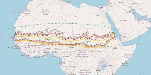
1- Borders of the Sahel according to various authors
To define the borders of the Sahel, Sivakumar and Wallace (1991) suggest the latitudes 10–15° N, while Nicholson and Palao (1993) propose the latitudes 10–20° N. Davy et al. (1976) identify the "morphological Sahel" between the isohyets of 100 mm and 700 mm/year. Agnew (1982) chooses the isohyets of 200 mm/year for the northern limit and 700 mm/year for the southern limit. Giri (1983) identifies the Sahel between the isohyets of 150 mm/year in the North and 650 mm/year in the South. Hulme (1992) uses the isohyets of 100–600 mm/year. The thresholds identified by the authors were maintained, but the isohyets was recalculated on the same series of data that we used in our proposal (i.e., the Climate Hazards Group InfraRed Precipitation with Station [CHIRPS] data, 1981–2023).