Africa
Giovanni Antonio Magini, Geografia cioè Descrittione universale della Terra., 1596 (1612)
Title of the volume: Geografia cioè Descrittione universale della Terra. Partita in due volumi, nel primo de’ quali si contengono gli Otto Libri della Geografia di Cl. Tolomeo, Nuovamente con singolare studio rincontrati, & corretti dall’eccell.mo sig. Gio. Antonio Magini Padovano pubblico Matematico nello studio di Bologna
Date: 1612
Author: Claudius Ptolemaeus (c. 100 – c. 175 AD)
Other author: Giovanni Antonio Magini (1555–1617)
Engraver: Girolamo Porro (1529–1600)
Publisher and place of publication: Paolo and Francesco Galignani, Padua
Plate execution tecnique: chalcography
Language: Italian
Location: Geography Library, Morbiato Collection, MORB.9
Notes on the volume: Giovanni Antonio Magini was a mathematician, astronomer, astrologer, cartographer, and geographer. Born in Padua, he studied between his hometown and Bologna, where in 1588 he was appointed professor of mathematics at the university, succeeding Ignazio Danti and being chosen over the other candidate, Galileo Galilei. He corresponded with Tycho Brahe, Ortelius, and Kepler, among others. He authored several astronomical works, including the Tabulae secundorum mobilium coelestium, published in Venice in 1585 and dedicated to the motion of the planets. He also produced the first printed atlas devoted to Italy, which began to be published in this form in 1616, shortly before his death; publication was completed by his son Fabio. From 1590 onward, Magini dedicated himself to the edition of Ptolemy’s Geographia, which was first published in Venice in 1596 by Galignani, under the title Geographiae universae tum veteris tum novae absolutissimum opus duobus voluminibus. Other known editions include those of Cologne (1597, 1608), Venice (1598, 1599, 1608, 1616 — the edition here examined), Arnhem (1617), and Padua (1620, 1621). The work is structured in two parts: the first contains the original text of Ptolemy, translated into Italian by Leonardo Cernoti, along with the author’s commentary on Book I; the second presents the 27 original maps, to which 37 modern geographic plates are added, derived mainly from the cartographic works of Gerardus Mercator and Abraham Ortelius, all extensively described and explained by the author. Magini’s decision to publish and enrich Ptolemy’s Geographia, and the widespread publication of the text in many cities, testify to the enduring interest of European intellectuals in Ptolemaic thought, despite more than a century of new geographical discoveries.
GEO-CARTOGRAPHIC DATA
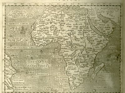
Scale: approx. 1:57,000,000
Graphic scale: –
Orientation: North at the top
Dimensions: 17 × 12.5 cm
Descriptive notes: While Ptolemy only knew and described the northern part of Africa, Magini introduces in the second volume of his Ptolemaic edition this “modern” map of the entire continent, which reproduces the 1582 map by d’Anania, itself inspired by Ortelius’s 1570 version. As was common at the time, a sea monster adorns the oceans — here located in the Oceanus Aethiopicus (Atlantic Ocean). The map is rich in detail, exemplified by the unusually high number of islands indicated in the Mar Rubrum (Indian Ocean). However, Zanzibar is absent, even though in Ortelius’s model it appears on the mainland along the western coast. Ortelius likely drew on a tradition that used the name “Zanzibar” to denote a population and region in southwestern Africa, while also referring to the Indian Ocean island as “Zenzibar”— a distinction Magini does not reproduce. The map features a wealth of place names both along the coasts and inland. The most important cities are represented by a white circle with a central dot. The main regions, indicated in uppercase, are all located north of the Equator: Barbaria, Melli, Guinea, and Nubia. While orography is sketched using the “molehill” technique, hydrography is richly delineated and especially detailed in the sub-equatorial zone, in keeping with the Ortelian model.
The Sahelian area is marked by a single river, the Niger, whose mouth is located in a large lake in the region of Medra. Heading northward, after a break in the course —p ossibly just a typographic gap at a place name — it resumes, flowing into Lake Borno, approximately identifiable with Lake Chad. It then continues westward, receives waters from various tributaries, and crosses a third lake marked with the symbol of a building at its center, before finally flowing into the Mare del Nort (North Atlantic). Also in line with the Ortelian model, the Zaire (Congo) River is depicted, with its sources placed in the western Ptolemaic lake, the same as those of the Nile. It flows into the Oceanus Aethiopicus after receiving three tributaries: Bancare, Vamba, and Bibi. In the southern part of the map, we find, among others, the large Infante River, which flows north to south and empties near the Cape de las Vacas, east of the Cape of Good Hope. Returning to the Sahel region, the western part, labeled Nigritarum regio, contains a succession of kingdoms from north to south: Tombutu, Gago, Guber, Gilolf, Dauma, Benin, Biafar, Mapan, Melegete, and Medra. A wide east–west mountain chain separates the Niger River basin from the coast of Guinea.
Bibliography
Baldini U. (2006). Magini, Giovanni Antonio. In: Dizionario Biografico degli Italiani. Roma, Enciclopedia Treccani, 67.
Betz R.L (2007). The Mapping of Africa. A Cartobibliography of Printed Maps of the African Continent to 1700. Utrecht, Hes & de Graaf.
Federzoni L. (2004). Cartografia e cultura. Brevi considerazioni sulla figura e sul sapere del cartografo. Geostorie. V, 12/1: 11-24.