Africa
Philipp Clüver, Introductionis in universam geographiam tam veterem, quam novam libri sex, 1624 (1661)
Title of the volume: Introductionis in universam geographiam tam veterem, quam novam libri sex (Introduction to Universal Geography, Both Ancient and Modern, in Six Books)
Date: 1661
Author: Philipp Clüver (1580–1622)
Other Author: Petrus Bertius (1565–1629)
Printers: Lodewijk Elzevier (1604–1670) & Daniel Elzevier (1626–1680)
Publisher and Place of Publication: Elzevier, Amsterdam
Plate execution tecnique: chalcography
Language: Latin
Location: Geography Library, Morbiato Collection, MORB.14.
Notes on the volume: A well-known humanist and geographer from Danzig, Philipp Clüver began his studies in Leiden—not so much in the field of law, which his father had chosen for him, but rather in history, geography, and antiquarian studies, which were more in line with his interests. Unable to rely any longer on his father’s financial support for this reason, Clüver was reluctantly forced to enlist in the army; this, however, allowed him to travel across Europe. He continued traveling even after leaving the military, thanks to financial support from his mother, collecting and elaborating data that he would later publish in his first geo-historical essays: Comentarius de tribus Rheni alveis et ostiis (1611) and Germaniae antiquae libri tres (1613). He returned permanently to Leiden in 1616, where he was honored in various ways (including a regular pension) and received the title of “Geographus academicus.” His later works, Sicilia antiqua (1619) and Italia antiqua (posthumously published in 1624), are also of great significance. However, his most successful book is Introductionis in universam Geographiam tam veterem quam novam libri VI, published posthumously in Leiden in 1624. The work is in six books: the first is dedicated to general considerations about the Earth, while the remaining five cover specific areas with brief descriptions and various human and historical insights. In this small-format edition, between Clüver’s text and the index, is inserted a Breviarium totius orbis terrarum una cum serie romanorum imperatorum by Petrus Bertius.
GEO-CARTOGRAPHIC DATA
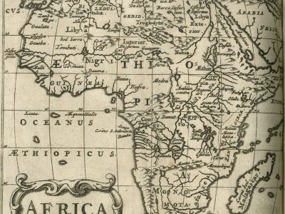
Scale: approx. 1:53,000,000
Graphic scale: –
Orientation: North at the top
Size: 12.5 × 13 cm
Descriptive notes and regional divisions: This depiction of the African continent features a wealth of hydrographic and orographic information and detailed territorial names. The identifiable regional divisions are: Aethiopia (notable for its considerable territorial extent), Barbaria, Guinea, Egypt, and Monomotapa. The Sahel region shows the same inconsistency already observed in earlier maps regarding the positioning of the Niger and Senegal rivers. In fact, following the model of Giacomo Gastaldi, Clüver draws a single great river called the Niger, which originates near Guangara, flows east-west, and widens approximately halfway through its course into a lake with an island at its center. The cartographic influence of Gastaldi—who worked mainly in the second half of the 16th century—was predominant until the early 18th century, when the two rivers began to be depicted as separate courses. The Mountains of the Moon (Montes Lunae) are shown, with the two large lakes that feed the Nile (according to Ptolemaic description) located to the north of them.
Bibliography
Betz R.L (2007). The Mapping of Africa. A Cartobibliography of Printed Maps of the African Continent to 1700. Utrecht, Hes & de Graaf.
Rizzo G.J. (2006). The Patterns and Meaning of a Great Lake in West Africa. Imago Mundi, 58/1: 84-85.
Alamgià R. (1931). Clüver, Philipp. In: Enciclopedia Italiana. Roma, Treccani.