Africa central
Ángel Fernández de los Ríos, Atlas geográfico de la tierra, 1849
Title of the volume: Atlas geográfico de la tierra: colección de mapas de las antiguas y actuales divisiones del globo, traducidos de la última edición del Atlas Clásico universal, publicado en francés (Geographical atlas of the World: A Collection of Maps of the Ancient and Current Divisions of the Globe, Translated from the Latest Edition of the Atlas Clásico Universal, Published in French)
Date: 1849
Author: Ángel Fernández de los Ríos
Publisher and place of publication: Oficinas y Establecimiento Tipográfico de La Ilustración y del Semanario, directed by D.G. Alhambra, Jacometrezo, 26. Madrid
Printing technique of the plates: White print on black paper
Language: Spanish
Location: Biblioteca di Geografia, MORB.32
Notes on the volume: The atlas, edited by Ángel Fernández de los Ríos, is an open adaptation of the second edition of Atlas classique universel de géographie ancienne et moderne, composé de 86 cartes dont 9 doubles dressé d’après les matériaux les plus récens by Victor Levasseur, published in Paris in 1839. Los Ríos (1821–1880) was a Spanish journalist, publisher, politician, historian, and urban planner who founded the newspaper Las Novedades, the first to reach wide circulation in Spain. It sometimes featured supplements rich in engravings and ornamentation. He also directed La Ilustración (1849–1857), El Semanario Pintoresco Español (1846–1855), and a Biblioteca Universal Diaria of historical, scientific, and literary works, which gained wide success thanks to its affordability and remarkable illustrations.
One of his most important and acclaimed geographic works was La Tierra. Descripción Geográfica y Pintoresca de las Cincos Partes del Mundo tomada del libro de Victor Levasseur, also published in Madrid by the Oficinas y Establecimiento Tipográfico and likewise inspired by Levasseur’s work. To this, he added information from studies and research by other European geographers and anthropologists, including Karl Ritter and Adriano Balbi. The resulting work was a volume rich in recent and accurate territorial data, including on the African continent, to which about 10 of the 290 pages are dedicated.
Closely related to this work is the Atlas geográfico de la tierra, whose modest size does not prevent the author from indulging, as usual, in ornamentation (for example, the spine of the cover features gold-stamped lettering) and in sophisticated illustrations. These correspond to the 77 plates of various sizes, unusually printed in white on black background, including a celestial planisphere, a solar system, a mappa mundi, and numerous historical maps. Seven plates are dedicated to African regions, three of which are relevant to the Sahel region. On page 5 there is a brief introduction to flat geographic representations and to the way different types of maps (of the world, nations, and regions, both topographic and not) and various scales of reduction should be understood. This introduction serves as a guide to facilitate better understanding and appropriate use of the atlas. Lacking statistical tables, a geographical glossary, and in general any accompanying texts to the maps, the small atlas serves as a true cartographic appendix to La Tierra.
GEO-CARTOGRAPHIC DATA
Scale:
Graphical scale: Leguas communes – Oras de camino
Orientation: North at the top
Dimensions: 5 x 3.5 cm
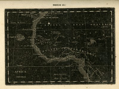
Descriptive notes: Plate number 65 of the atlas closely replicates that of V. Levasseur, both in toponymy and in the choice of title and graphical scale; the only changes are the coloring and the language, Spanish instead of French. The faithfulness to Levasseur reflects a scientific rigor, with a tendency to include only verified information and confirmed place names at a crucial stage of European exploration and knowledge acquisition about the African continent. For example, the settlement of Bakel—still existing today—is accurately placed on the Senegal River; similarly, the towns of Sego and Djenne appear on the Niger River, before what appears to be Lake Debo, although it is not labeled.
Unprecedented is the representation of the Niger River’s course, which, after the city of “Ten-Bouctoue,” splits into two dashed lines, likely illustrating uncertainty about the actual course of the river: one branch continues eastward and disappears into the Great Desert; the other heads southeast, crossing “Guinea Septentrional” near the city of “Sockoto” and reaching the Atlantic. At the heart of the continent lies “Soudan,” with several notable additions: particularly south of “Lag Tehad,” a high concentration of small, almost parallel waterways is depicted. Although none are named, one can recognize the Yobe River flowing westward and the Chari and Cross Rivers, tributaries to the lake’s southern shore. Two other rivers, placed on the lake’s eastern shore, flow from two other lakes which—based on their position—recall Lakes Semegonda and Fittre, though not named on the map. These elements could be interpreted as representing the extended, seasonally fluctuating water basin of Lake Chad.
Another novelty in this area is the appearance of the city of “Kouka” on the southwestern shore of Lake Chad, which is accurately placed. Another map included in the atlas reproduces the Nile region from its supposed source to its mouth: the origins are located at the confluence of two streams, one coming from Donga and the other from Kordofan; after their confluence, the Nile flows northeast and for a short stretch skirts the “Montañas de la Luna”—showing that, in the case of the Nile, several errors still persisted.
On the other hand, the watercourse rising from “L Dembea” and flowing into the Nile near the region of “Sennaar” is correctly positioned as the Blue Nile emerging from Lake Tana—clearly showing that Europeans had reached this point by 1850, though not beyond the Ethiopian highlands.
Bibliography
DE LOS RIOS, Angel Fernandez. La tierra descripcion geografica y pintoresca de las cinco partes del mundo tomada del libro de Victor Levasseur . La Ilustración, 1849.
Reference websites
https://repositorio.bde.es/handle/123456789/35367?mode=full
https://dbe.rah.es/biografias/9405/angel-fernandez-de-los-rios