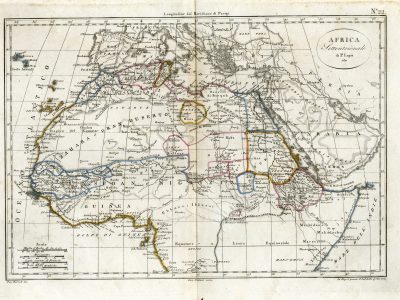
Africa settentrionale
Luigi Maria Galanti, Atlante Universale e Portatile di Geografia Antica e Moderna, 1817
Title of the volume: Atlante Universale e Portatile di Geografia Antica e Moderna (Universal and Portable Atlas of Ancient and Modern Geography)
Date: 1817
Author: Luigi Maria Galanti (1765–1836)
Engravers: Marco Di Pietro, Gennaro Bartoli, Gennaro Galiani
Publisher and place of publication: Gabinetto Letterario, Naples
Plate execution technique: Calchography with hand coloring
Language: Italian
Location: Geography Library, MORB.29
Notes on the volume: This is a re-edition of L’atlante in 32 carte (The Atlas in 32 Maps) published in Naples in 1813 by the Gabinetto Letterario. Previously known as “Società Letteraria”, the Gabinetto Letterario played a significant role in the cultural production of the Kingdom of Naples between the 18th and 19th centuries. It counted among its key figures the brothers Galanti. The elder, Giuseppe Maria, undertook an extensive work of demographic description and updating of the Bourbon Kingdom’s condition, published in 1786 as Nuova descrizione storica e geografica delle Sicilie (New Historical and Geographical Description of the Sicilies). The younger, Luigi Maria, although less well known, was a prominent teacher and geographer in Naples between 1805 and 1836; he was the author of L’atlante in 32 carte, which clearly drew from Atlas complet du Précis de la Géographie universelle by M. Malte-Brun (1812), with maps by Pierre Lapie, reflecting the influence of French culture on Neapolitan publishing of the time.
In the atlas under examination, there are three maps dedicated to Africa: a general map based on the one created in 1810 by Jean-Baptiste Poirson, and two others, one of North Africa (here reproduced) and the other of Southern Africa, both derived from maps made by Lapie in 1811. There is no accompanying text to help interpret or elaborate on the cartographic information. In 1847, the publisher Giustino Merolla oversaw a re-edition using the same title page and copperplates from the Atlante Universale e Portatile.
GEO-CARTOGRAPHIC DATA
Scale:
Graphical scale: Italian miles (60 per degree) – Myriameters – Common French leagues – Large Arabic miles
Orientation: North at the top
Dimensions: 30.5 x 21 cm
Descriptive notes: This map of North Africa is number 22 in the atlas. The simple oval cartouche at the top right reads: “AFRICA Settentrionale di P. Lapie 1811.” A constant feature of the cartographic representations in this work is the use of colored lines highlighting political borders and coastal areas. In the case of North Africa, the land areas enclosed by these lines represent regions inhabited by either nomadic or sedentary communities, corresponding to regional African states: examples include “Egypt,” “Nubia,” “Abyssinia,” “Fezzan,” “Burnu,” and “Darfur.”
It is important to note that the concept of territoriality and borders on which this type of cartography is based—typically European—and more broadly, the spatial organization of modern Western states, was entirely foreign, if not opposed, to that of the peoples living in Africa at the beginning of the 19th century.
The Atlantic coast, dotted with place names, ports, and river mouths, resembles an expansive “emporium” facing the ocean, with specialized areas for every type of trade; the interior, in contrast, is marked by vast empty spaces. This reflects the lack of knowledge about these regions, which would only be thoroughly explored by Europeans over the 150 years following the creation of this atlas. The most substantial geographical information, both in quantity and quality, concerns the regions along the Nile and the Atlantic coastal areas (modern-day Senegal and Gambia), which were the most frequently visited by European merchants for trade.
South of the “Zahara,” the Niger River is depicted, originating from a mountain range labeled the “Mountains of Kong.” It flows westward, passing through “Tombouctou,” “Haussa,” and “Kano” before seemingly converging into what appears to be a sea of sand dunes in the heart of Africa: the “Ouangarah.” From there, according to contemporary scholars’ and explorers’ hypotheses, the river was believed to flow south-southwest and empty into the Gulf of Guinea. This hypothetical final stretch of the river is marked on the map by a dashed line that splits near the Atlantic Ocean.
East of what is presumably Lake Chad, two smaller lakes are shown. The first, unnamed, probably corresponds to what is labeled as Lake Semegonda in other maps. The second is “Lake Fittre.” The Sahelian region between the Gambia River and the Nile is labeled “SUDAN or NEGROLAND” (Sudan o Nigrizia), along with the “GREAT DESERT”—both areas that would fuel the most curiosity and exploratory fervor for the rest of the 19th century.
Despite some effort to indicate which features are speculative, the map is highly inaccurate. This is demonstrated by the many small water bodies at the center of the map—most of which either do not exist in those forms or are seasonal—as well as the vast mountain ranges (graphically rendered using the “molehill” technique), many of which are fictional, such as the recurring “Mountains of the Moon” (Monti Al-Qamar). This phase generally features both older, incorrect elements—drawn from outdated maps or merchant-traveler reports—and more recent, verified names: among the latter, between “Sego” and “Tombouctou” along the Niger River, the map correctly includes “Lake Dibbie,” whose accurate location dates to 1805 thanks to the explorations of Mungo Park. On the lake’s shores appears the name of the native “jenna” people, already mentioned in the 12th century by the geographer Al-Idrisi—a community active along the salt and gold trade routes that passed through Timbuktu.
Bibliography
VALERIO, Vladimiro. Italian Atlases and their makers 1770-1830. Map Collector Publ., 1988.
VALERIO, Vladimiro, et al. Late Eighteenth-and Early Nineteenth-Century Italian Atlas. In: Images of the World. USA, 1997. p. 257-300.
VALERIO, Vladimiro. Atlanti napoletani del diciannovesimo secolo (1806-1860). L. Regina, 1980.
CASTALDO, Marianna. L’editoria nel Regno di Napoli e la circolazione del libro francese durante il XVIII secolo. Rivista di Terra di Lavoro», ix, 2015, 1-2: 37-48.
SARNO, Emilia. Luigi Maria Galanti. Un geografo dimenticato del Primo Ottocento napoletano. Bollettino della Società Geografica Italiana, 2014, 7: 621-635.
RIZZO, Gerald J. The patterns and meaning of a great lake in West Africa. Imago mundi, 2006, 58.1: 80-89.
Reference websites
https://www.fondazionemarcobesso.it/cataloghi/fs_photosprints/index/page:416
https://www.libreriantiquaria.com/it/catalogo/geografia/opere-di-geografia-generale-e-atlanti/18111-atlante-universale-e-portatile-di-geografia-antica-e-moderna-formato-sulle-carte-de-migliori-e-piu-recenti-geografi-e-sulle-ulti.html
https://data.bnf.fr/15240617/pierre_lapie/