Date: 1777 (first edition, Geography Library); 1785 (second edition, Morbiato Collection)
Author: Christiaan Andreas Sepp (1712-1775)
Printer: Giammaria Bassaglia
Plate execution technique: Watercolored chalcography
Language: Italian
Location: Geography Library, ATL PRE 7 (1); Geography Library, Morbiato Collection, MORB. 19
Notes on the volume: The two volumes constitute the first (Library copy) and second (Morbiato Collection copy, lacking frontispiece) editions of the Nuovo atlante portatile (New Portable Atlas) printed in Venice by Giammaria Bassaglia in 1777 and 1785 respectively. A third edition was published there in 1796 by Giacomo Storti. The atlas derives from the work Geographische Oefening by the designer and engraver Christiaan Andreas Sepp (1712-1775), particularly known for his engravings dedicated to the plant and animal world. Of the 22 miniature maps in his small atlas, he was simultaneously the designer and engraver. The text was first printed in Dutch in 1758 in Amsterdam, where Sepp lived, by Frans Houttuyn. In 1760, he sold Sepp’s copperplates to Jan Herman Schneider, with the right to publish a French edition: this came to light that same year with the title Atlas des enfans [sic] and knew great success with six official editions, in addition to many pirate editions. Among the pirate editions, both the one published by Bartholomew Vlam in Amsterdam in 1772 and the one published in Lyon by Bruyset in 1774 falsely attribute the original maps to the famous French cartographer Guillaume Delisle. The Bassaglia edition reproduces this false attribution. The work constitutes an early example of a school atlas, proposing a new method for teaching geography to children: first, data is reduced to avoid information overload; then, each map is accompanied by a chapter of questions and answers that guides the student in reading the map, thus supporting learning through the dual direction, visual and textual; this interdependence between map and text is accentuated by the fact that geographical elements are identified on the maps through a symbolic system of numbers and letters that are explained in the text. In the preface to the Venetian edition by Bassaglia, the desire to be simpler and clearer than the original work is expressed, choosing “a plain style, and a language for children” (from the Preface); it also lists a series of choices considered improvements, related to both content and the order in which it is treated. Like the Atlas des enfans, the volume also contains a short treatise on the use of globes accompanied by two plates, bringing the total number of illustrations to 24 compared to Sepp’s 22.
GEO-CARTOGRAPHIC DATA
Scale: Approximately 1:100,000,000
Graphic scale: –
Orientation: North at the top
Size: 13.5 x 11.5 cm
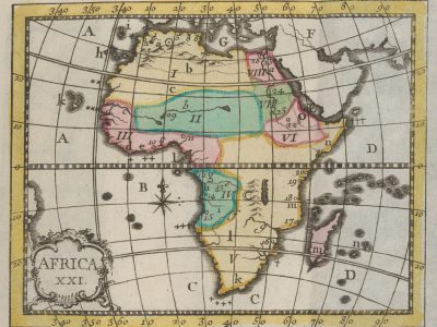
Descriptive notes and regional divisions: The small map of Africa is reproduced identically in the two editions of the Atlas. Characterized by the number XXI, reported within the cartouche along with the name of the continent, its reading is facilitated by nine pages of questions with relative answers. After a first part dedicated to defining very briefly and roughly the climate, government, religions, and characteristics of the inhabitants, the text begins to explain the alphanumeric symbologies corresponding to the territorial subdivisions. Roman numerals identify eight main areas, mostly further subdivided:
- Barbary, divided into: Proper Barbary (a), Biledulgerid (b), Sahara (c);
- Nigritia;
- Guinea, divided into: Grain Coast (d), Ivory Coast (e), Gold Coast (f);
- Congo, divided into the Kingdoms of: Loango (g), Congo (h), Angola (i);
- Kaffraria, divided into: Land of the Hottentots (k), Monomotapa (l), Zanzibar Coast (m), Ajaan Coast (n);
- Abyssinia, which includes the Coast of Abex (o)
- Nubia;
- Egypt.
Subsequently, the main islands are listed, again with lowercase letters, and cities of the continent, concentrated mainly along the coasts and indicated by Arabic numerals between 1 and 26. Regarding hydrography, seven major rivers are reported: the Nile (a) and the Niger (“The Negro”) (b) are given particular emphasis, underlining how they fertilize, respectively, Egypt and Nigritia with two annual floods in the same period; the others are: the Senegal (c), the Gambia (d), the Cairo (e), the Cuneni (f) and the Cuama (g). Furthermore, the main capes observable along the coasts and the major mountains of Africa are listed. The latter are only two: Mount Atlas, indicated by a point surrounded by a circle, which crosses all of Barbary, and the Mountains of the Moon, identified by a crescent moon and located in Kaffraria. The chapter concludes with a mention of the borders, extension, and coordinates of Africa.
Bibliography
King G. (1996), Miniature antique maps: An illustrated guide for the collector. Tring, Map Collector Publications.
Huguet F. (1997). Les Livres pour l’Enfance et la Jeunesse de Gutenberg à Guizot. Les collections de la Bibliothèque de l’Institut National de Recherche Pédagogique. Paris, Institut national de recherche pédagogique, pp. 272-273..
P.C.J. Van Der Krogt (2020). De Atlas des Enfans (1758-1857). Een Amsterdams aardrijkskundeleerboek met blinde kaarten in tachtig uitgaven. Caert-Thresoor, 39, n. 1.