Title of the volume: Teatro del mondo di Abraamo Ortelio: nel quale si dà notizia distinta di tutte le provincie, regni e paesi del mondo (Theatre of the World by Abraham Ortelius: in which a detailed account of all the provinces, kingdoms, and countries of the world is given)
Date: 1724
Author: Abraham Ortelius (1527-1598)
Publisher and place of publication: Lovisa, Venice
Plate execution tecnique: Chalcography
Location: Geography Library, ATL PRE 11
Notes on the volume: Abraham Ortelius’s Theatrum Orbis Terrarum is considered the first modern atlas. First published in 1570 in Antwerp, it consisted of 70 maps. Ortelius selected the best contemporary maps, standardizing them in size and style, and applied a consistent geographic grid. The engraving work was entrusted to Frans Hogenberg.
The uniform representation of the Earth reflected the principles of equality and tolerance to which Ortelius adhered, in an era of deep religious divisions. Maps had a persuasive power, shaping the reader’s memory and understanding of the world.
The Theatre of the World replaced the traditional tripartite division of the continents with a quadripartite structure, introducing the American continent. The frontispiece of the original edition depicted the ecumene in the form of four hierarchical allegorical female personifications, with Europe at the top as the holder of knowledge.
The 1724 Venetian edition, published by Domenico Lovisa, derives from a pirated edition of Christoffel Plantin’s version (Spieghel der Werelt, Antwerp, 1579). However, it dedicates more space to the territories of the Republic of Venice and introduces modifications to some maps, incorporating new information gathered over nearly two centuries of exploration.
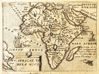
GEO-CARTOGRAPHIC DATA:
Scale: approx. 1:94,000,000
Orientation: North at the top
Dimensions: 10.5 x 8 cm
Descriptive notes: Ortelius’s representation of Africa closely follows the famous wall map created by the Venetian cartographer Giacomo Gastaldi in 1564, particularly in terms of place names, their locations, the absence of the Ptolemaic “Mountains of the Moon,” and hydrography. However, it differs from Gastaldi’s map in the reduced longitudinal extent of the continent, which results in a more central positioning of the Cape of Good Hope and a generally sharper shape.
The 1724 edition is significantly smaller in size, which leads to fewer details compared to Ortelius’s original: Orography is not indicated; the number of place names and the hydrographic network are significantly reduced; cities are represented by stylized symbols of two adjacent buildings.
The title Africae Tabula Nova appears in a simple cartouche at the bottom left. Following tradition, some decorative elements are present, including two sailing ships navigating the “Oceano Aetio[picus]” (Southern Atlantic Ocean) and the “Mare Rvbrvm” (Indian Ocean), where a sea monster is also depicted.
A curious feature is the interruption of the Nile River near the city of Gaoga, possibly related to the omission of a place name present in the model. Regarding hydrography, the Sahel region features a single river, identified near its mouth in the Atlantic Ocean as “flu. Niger”. Its sources are located, according to Gastaldi’s model, in a “Lac Niger” in Central Africa. From there, the river flows northwards to a second lake near “Zafara”, roughly corresponding to Lake Chad. It then bends westwards toward the Atlantic, receiving tributaries and passing through a third lake along the way. In the southern part of the continent, only one river from Ortelius’s original map is labeled: the “Cuama” (Zambezi).
Next to Madagascar, the original text note is preserved: “Hec insula ab incolis madagascar ad Hispanis S. Laurentij, olim Memithias Ptol Cer neforte Plindicitur”, although transcription errors are evident.
The Zanzibar region is omitted along the western coast, possibly due to the fluctuating use of the toponym since Ortelius’s time.
Another map in the volume, Presbiteri Ioaannis sive Abissinor Imperi descriptio, is dedicated to the legendary kingdom of Prester John, a rich Eastern realm historically associated with various locations between India and Ethiopia.
This map is particularly rich in iconographic elements, including: a decorative sailing ship off the eastern coast; trees north of “Borno Lacus”; two elephants along the course of the Niger River.
Unlike the general map, the Niger River on this map disappears underground for about sixty miles before re-emerging in a lake, as indicated by the note:
“Hic Niger Fluvius se subterterram conderis post 60 Milliaria denuo in Lacum emergit”.
The Nile River, on the other hand, flows uninterrupted from the Ptolemaic lakes where it originates to the Mediterranean Sea, differing from its interrupted course in the general Africa map.
Bibliography
Betz R.L (2007). The Mapping of Africa. A Cartobibliography of Printed Maps of the African Continent to 1700. Utrecht, Hes & de Graaf.
Cerulli E. (1935). Prete Gianni. In: Enciclopedia Italiana. Roma, Treccani.
Daniele E.A. (2018). I ritratti del mondo: personificazioni dell’ecumene in età moderna. PhD Dissertation, University Ca’ Foscari Venezia.
Mangani G. (2006). L’atlante come raccolta del sapere. Nascita di un nuovo mezzo di comunicazione. GEOmedia. 10/1: 54-58.
Visentin M. (2017). Fascino e potere del Theatrum Orbis Terrarum di Ortelio, Charta. 154: 26-31.