Title of the volume: Atlas encyclopédique, contenant la géographie ancienne, et quelques cartes sur la géographie du moyen âge, la géographie moderne, et les cartes relatives à la géographie physique (Encyclopedic Atlas, containing ancient geography, and some maps on the geography of the Middle Ages, modern geography, and maps relating to physical geography) [2 vols.]
Date: 1789
Author: Rigobert Bonne (1724-1794), Nicolas Desmarest (1725-1815)
Engraver: Pietro Scattaglia (c. 1739 – 1803)
Place of publication: Padua
Plate execution technique: Chalcography
Language: French
Location: Geography Library, ATL.ANT.36.1-2
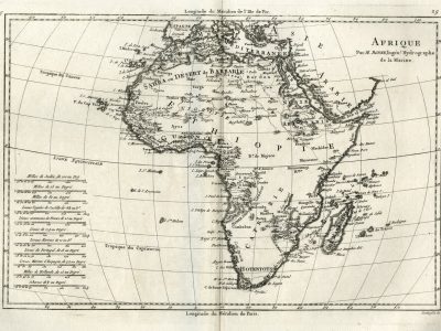
Notes on the volume: The atlas, in an edition printed in Padua in 1789, is divided into two volumes containing, respectively, 93 maps in the first and 47 in the second, for a total of 140 maps; the 29th map of the first volume, proposed here, represents the African continent. Rigobert Bonne, among the main cartographers of the 18th century, became First Ingenieur-Hydrographe de la Marine in 1773, succeeding Jacques Nicolas Bellin. Also in relation to this role, which led him to specialize in the production of nautical charts, his maps reach their peak of precision and detail mainly along the coastal stretches. The Atlas Encyclopédique, his last work, was first published in Paris between 1787 and 1788, just before the beginning of the French Revolution, as part of the Encyclopédie méthodique, also known as the “Panckoucke” Encyclopedia, a monumental work elaborated between 1872 and 1832, whose aim was to perfect the Encyclopédie ou Dictionnaire raisonné des sciences, des arts et des métiers by Diderot and D’Alembert.
GEO-CARTOGRAPHIC DATA
Scale: Approximately 1:37,000,000
Graphic scale: Milles de Judeè, de 100 au Deg, Milles de 75 au Degreè, Milles de 60 au Degreè, Lieues l’egales de Castilille de 26 23 au De, Lieues communes de France de 25 au Degreè, Lieues de 22 2/9 au Degreè, Lieues Marines de 20 au De, Lieues de Portugal, de 18 au Degreè, Lieues Marines d’Espagne, de 17 ½ au Degreè, Milles de Hollande , de 15 au Degreè, Schoenes de 1/9 au Degreè
Orientation: North at the top
Size: 25 x 36.5 cm
Descriptive notes and regional divisions: The map presents numerous toponymic, hydrographic, and orographic elements along the coasts, which become sparser in the center of the continent, eventually giving way to numerous “white spaces”. In addition to the author’s hydrographic and nautical specialization, this also finds its reasons in the scarce knowledge of the time: the exploration of Africa by Europeans would in fact be completed only in the following century. The map, in which the relief is rendered in molehill style, reports a large number of different graphic scales; the great precision and competence of the cartographer, who applies the conical projection known by his name, are also expressed in the choice to propose the degrees of longitude referred, in the lower part, to the Meridian of Paris and, in the upper part, to the Meridian of Ferro Island. The map is distant from the decorative overload that accompanied the work of his predecessors and is an excellent example of the taste for simplicity that, also thanks to Bonne’s teaching, began to predominate in French cartography in the last quarter of the 18th century: for example, there are no decorative cartouches, but the title is placed in an essential frame.
The African continent is divided into “Barbary”, “Guinea”, “Ethiopia”, “Nigritia”, “Egypt”, “Nubia”, “Abyssinia” and “Kaffraria”; the Sahara desert is called “Sahra or Desert of Barbary”. The Sahel area does not show a precise subdivision into kingdoms, as is sometimes found, but particular attention is paid to place names. In fact, there are numerous names of cities that multiply along the coasts; many reliefs are also reported close to the coast of Guinea. Regarding hydrography, the sources of the Senegal River are located in the reliefs southwest of Kekia and in a lake not far from the source of the Niger River; the latter, after its characteristic arching in the Tomboctu area, flows by bifurcating into the two lakes of Reghebil and Semegonda, in turn surrounded by mountain reliefs. Unlike the African maps of Santini (1776) and Zatta (1782), the Mountains of the Moon are no longer represented.
Bibliography
Lizarraga Echaide J.M.(2010). Bonne, Rigobert. In: Cuesta Domingo M. e Luque Talaván M., a cura di, Imago Mundi. Mapas e Imprenta, Madrid. Madrid, Universidad Complutense de Madrid: 182.