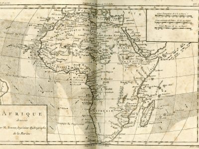
Afrique dressée par M. Bonne
Guillaume Thomas François Raynal, Atlas de toutes les Parties Connues du Globe Terrestre dressé pour l’histoire philosophique et politique des établissements et du commerce des européens dans les deux Indes, 1780
Title of the volume: Introductionis in universam geographiam tam veterem, quam novam libri sex (Introduction to Universal Geography, Both Ancient and Modern, in Six Books)
Date: 1780
Author: Guillaume Thomas François Raynal (1713-1796)
Other Author: Rigobert Bonne (1724-1794)
Engraver: André Gaspard (1752-1837)
Publisher and place of publication: Paris [edition lacking publication details]
Plate execution technique: Chalcography
Language: French
Location: Geography Library, Morbiato Collection, MORB.24
Notes on the volume: Guillaume Thomas François Raynal, born in 1713, initially pursued an ecclesiastical career, then abandoned it to dedicate himself to the independent production (he was a writer, publisher, and bookseller) of essays on history and politics. The atlas is attached to the work Histoire philosophique et politique des établissements et du commerce des Européens dans les Deux (Indes Philosophical and Political History of the Settlements and Trade of the Europeans in the Two Indies), an extensive history of international trade in the 18th century, first published in Amsterdam in 1770 and then republished in various editions. On the occasion of the second revision (Geneva, 1780), which benefited from Diderot’s collaboration, the work was published in ten volumes, to which this atlas was added, containing 49 maps (of which the one dedicated to Africa is the fifth), created by Rigobert Bonne. This fundamental work of the Enlightenment, which widely criticizes the Church, politics, and society, marked the peak of Raynal’s fame but also caused him unpleasant troubles: King Louis XVI himself in 1781 ordered Raynal’s arrest, the seizure of his assets, and the burning of his book.
GEO-CARTOGRAPHIC DATA
Scale: 1:37,000,000
Graphic scale: Portuguese Leagues, 17½ to a Degree; Common French Leagues, 25 to a Degree; Marine Leagues, 20 to a Degree.
Orientation: North at the top
Size: 32 x 21.5 cm
Descriptive notes and regional divisions: A simple frame contains the title of the plate and the cartographer’s name: “Afrique dressée Par M. Bonne, Ingénieur-Hydrographe de la Marine” (“Africa drawn by Mr. Bonne, Engineer-Hydrographer of the Navy”). Like most maps drawn by this author, this one also shows a high density of toponymic, hydrographic, and orographic elements along the coasts; entering the continent, however, these thin out and give way to large white spaces. Until the early 19th century, indeed, few areas of inner Africa were known with certainty to Europeans, whereas their commercial activities had allowed them to know in detail the coastal features of the continent. The modernity of Bonne’s map lies precisely in the choice of scientific rigor and the consequent renunciation of including unknown and undocumented elements, at the risk of leaving large expansions of territory empty. The only concession to the ornamental dimension is the adoption, for the relief, of the traditional and pictorial technique of “molehills”. The wide usability of the map is ensured by the reference to different graphic scales and two different reference meridians: in the lower part, indeed, the degrees of longitude are referred to the Paris Meridian, while in the upper part to the Ferro Island Meridian. The hydrographer Bonne also reports, in line with his expertise, the depths of the waters surrounding Africa and the directions of currents, highlighted through the use of arrows.
The regional divisions present in the African continent are: “Upper Guinea”, “Lower Guinea”, “Ethiopia” (of considerable size), “Sahara or Desert of Barbary”, “Egypt”, “Nubia”, “Abyssinia”, “Congo” and “Kaffraria”. As is characteristic of all 18th-century atlases examined, the Mozambique Channel is indicated; the Mountains of the Moon are no longer present, which we still find in both Santini (1776) and Zatta (1782). From the Analyse Succincte that opens the volume, we learn that the cities marked with an asterisk are those named in the pages of the Histoire philosophique et politique… Examining the Sahelian area, it is noted that Senegal and Niger are depicted as distinct rivers, with sources on the two opposite slopes of a mountain range: specifically, the Senegal originates from Lake Maberia and then flows westward without giving rise to lakes along its course, as often found instead in previous maps; the Niger instead rises towards Tombut from where it begins to flow eastward, ending its course in Lake “Bournou”.”
Bibliography
Leca-Tsiomis M. (2010). Guillaume-Thomas Raynal, Histoire philosophique et politique des établissements et du commerce des Européens dans les deux Indes. Edition critique. Recherches sur Diderot et sur l’Encyclopédie. 45: 175-177.
Lizarraga Echaide J.M. (2010). Bonne, Rigobert. In: Cuesta Domingo M. e Luque Talaván M., a cura di, Imago Mundi. Mapas e Imprenta. Madrid, Universidad Complutense de Madrid: 182.
Maturi W. (1935). Raynal, Guillaume-Thomas-François. In: Enciclopedia Italiana. Roma, Treccani.