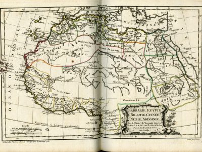
Barbarie, Egypte, Nigritie, Guinee, Nubie, Abissinie
Gilles Robert & Didier Robert de Vaugondy, Nouvel atlas portatif, 1757 (1762)
Title of the volume: Nouvel atlas portatif destiné principalement pour l’instruction de la jeunesse, & precedé d’un discours sur l’etude de la geographie par le S. Robert de Vaugondy (New Portable Atlas Primarily Intended for the Instruction of Youth, & Preceded by a Discourse on the Study of Geography by Mr. Robert de Vaugondy)
Date: 1762
Author: Gilles Robert de Vaugondy (1688-1766)
Other author: Didier Robert de Vaugondy (1723-1784)
Engraver: cartography, E. Dussy (18th century); cartouches and frames, J. Arrivet (18th-19th century)
Publisher and place of publication: Robert de Vaugondy, Paris
Plate execution technique: Chalcography
Language: French
Location: Geography Library, Morbiato Collection, MORB.22
Notes on the volume: Gilles Robert de Vaugondy was géographe du roi from 1734; in 1751, the same title was also attributed to his son Didier Robert, who joined his father in his activity, further expanding it. Gilles often signed his maps with the name “Robert”, while his son always signed as “Robert de Vaugondy”, often adding “filio”. Gilles took up cartographic activity after partly inheriting and partly purchasing the material produced by Nicolas Sanson (1600-1667), the “father” of French cartography. The Atlas Universel is the best-known work of the de Vagoundys. First published in 1757, it saw its most complete edition in 1786 and was reprinted until 1799. For the first time in France, this atlas gave readers the opportunity to subscribe to the fascicles that were gradually published at an affordable price, a feature that made it accessible to a wide audience. The list of 650 subscribers to the first edition, both in the large format costing 120 livres and the small format costing 96 livres, informs us that among the major buyers were primarily booksellers and cartographers, followed by diplomats, magistrates, secretaries of the royal household, military personnel, doctors, and ecclesiastics. The cost, while still the prerogative of a wealthy class, was lower compared to that of contemporary atlases, without compromising the quality of the product: to ensure their users updated and complete maps, the De Vagoundys spared no effort in searching for reliable sources, such as the updated geographical information possessed by the French Navy, which they drew upon for the maps of South America and Canada. This also explains the great editorial success of the work. While in France subscribers were mainly concentrated in Paris, Bordeaux, and Lyon, abroad the work was sold, among other places, in London, Berlin, and Fribourg.
The edition in the Morbiato collection consists of 52 geographical maps, of which a complete index is provided at the beginning along with a list of place names. The actual atlas is preceded by a Discours sur l’étude de la Géographie by Robert de Vaugondy himself. Particularly noteworthy is the choice to inaugurate the series of plates with four thematic planispheres: the same base map assumes a different theme by activating with color, each time, one of the three legends relating, roughly, to ethnicity, religion, or skin color of the inhabitants. In the fourth map, the colors distinguish, instead, the continental boundaries, introducing the political-administrative theme that dominates the rest of the plates.
GEO-CARTOGRAPHIC DATA
Scale: Approximately 1:250,000,000
Graphic scale: Echelle, Mille pas géométriques de 60 au dég, Lieues Marines ou d’une Heure
Orientation: North at the top
Size: 37.5 x 25.5 cm
Descriptive notes and regional divisions: Map No. 40 of the atlas depicts the northern part of Africa. It follows a general representation of the continent (map No. 39, not shown here), whose salient features are: the correct positioning of the source of the Nile in Lake “Dambea” (Lake Tana), according to the cartographic scheme outlined by Almeida more than a century earlier but long ignored; the absence of the Mountains of the Moon and the two Ptolemaic lakes, replaced, in the center of the continent, by a lake that stretches in a North-South direction and bears the indication “Grand Lac Marawi” (Lake Malawi or Nyasa); the separation of the courses of the Senegal and Niger rivers: the former originates in Lake “Maberia” (Lake Debo) and flows into the Atlantic, the latter has its course between a point located on the opposite side, with respect to the Senegal, of a watershed relief and the great lake of Bornou (approximately corresponding to Lake Chad). Compared to the general map of the continent, the one presented here is characterized by a larger scale and the consequent presence of more detailed geographical information. For example, the Sahara desert, called “Sara ou Grand Desert”, presents a series of further subdivisions: “Désert de Zanhaga”, “Désert de Zuenziga”, “Désert de Targa ou d’Hayr”, “Désert de Lemta” and “Desert de Berdoa”; along the course of the Senegal, the Gouina falls are also indicated (“saut de la roche gouina”); of the Niger, various toponyms are indicated (including “Guien” and “Nil des Negres”); furthermore, a new hydrographic element is reported, namely “la Gazelle R.”, a river along whose course lies a lake on which the city of Gaoga is located, northeast of the Niger. The relief is rendered, throughout the atlas, with the molehill technique, and cities are identified by the use of italics combined with the symbol of a small circle.
The neoclassical-style cartouche, the work of engraver Arrivet, bears the indication: “BARBARIE, EGYPTE, NIGRITIE, GUINÉE, NUBIE, ABISSINIE. Par le S. Rober de Vaugondy Geog? ord? du Roi, et de S.M. Pol? Duc de Lorr? Et de Bar, et de la Sociètè Royal de Nanci. Avec privilege” (the question marks are part of the original text).
Bibliography
Almagià R. (1937). Gilles-Robert de Vaugondy. Enciclopedia italiana, Roma, Treccani.
Cusimano G. & D’Agostino G., eds. (1986). L’Africa ritrovata. Antiche carte geografiche dal XVI al XIX secolo. Palermo, Quaderni del “Servizio Museografico” della Facoltà di Lettere e Filosofia dell’Università di Palermo: 226.
Hofmann C. (2000). La genèse de l’atlas historique en France (1630-1800): pouvoirs et limites de la carte comme «œil de l’histoire». Bibliothèque de l’École Des Chartes, 158/1: 97–128.
Pedley M. S. (1984). New Light on an Old Atlas: Documents concerning the Publication of the “Atlas Universel” (1757). Imago Mundi, 36: 48-63.
Pedley M. S. (1979). The Subscription List of the 1757 Atlas Universel : A Study in Cartographic Dissemination. Imago Mundi, 31: 66-77.
Vladimiro V. (1997). Late Eighteenth- and Early Nineteenth-Century Italian Atlases. In: John A. Wolter J.A. & Grim R.E., eds., Images of the World. Washington, Library of Congress: 257-300