Carte d’assemblage de l’Afrique
Philippe Vandermaelen, Atlas Universel de Géographie Physique, Politique, Statistique et Minéralogique, 1827
Title of volume: Atlas Universel de Géographie Physique, Politique, Statistique et Minéralogique
Date: 1827
Author: Philippe Vandermaelen (Brussels, 1795 – Molenbeek, 1869)
Lithographer: Henry Ode
Publisher and place of edition: Ph. Vandermaelen, Bruxelles
Printing tecnique of the plates: hand-watercolored lithograph
Language: French
Location: Biblioteca di Geografia, CART.MORBIATO.52
Notes on the volume: The first edition of the Atlas Universel de Géographie Physique, Politique, Statistique et Minéralogique, sur l’echelle de 1/1641836 ou d’une ligne par 1900 toises, dresse par Ph. Vandermaelen, Membre de la Societe de Geographie de Paris, d’apres les meilleures cartes, observations astronomiques et voyages dans les divers Pays de la Terre, was published in 40 fascicles of 10 maps each, between 1825 and 1827. Author, and publisher, was the self-taught Belgian cartographer Philippe Vandermaelen, founder of the private cartographic establishment Établissement Cartographique de Bruxelles. He created something entirely new—indeed, this atlas holds several noteworthy distinctions. It was the first atlas to use the same scale — specifically the large scale of 1:1,641,836 — for all parts of the world. It includes the first large-scale maps of many territories recently explored by Europeans, and it was the first atlas produced using the new technique of lithography. Moreover, the maps, in conical projection, were designed to be ideally assembled into a three-dimensional globe with a diameter of about 7.75 meters. At least one copy of the globe was produced and displayed in the library of Vandermaelen’s Établissement Géographique.
The complete work, in folio format, is divided into six parts: the first dedicated to Europe; the second to Asia; the third to Africa; the fourth to North America; the fifth to South America; and the sixth to Oceania. The total number of maps is 737, plus 6 index maps. The Museum of Geography received as a donation from Armando Morbiato the unbound parts 2 (Asia), 3 (Africa), and 5 (South America). The Africa section consists of one general overview plate and 60 separate maps. Areas of the plates not occupied by cartographic elements are often enriched with descriptive, statistical, and historical notes.
GEO-CARTOGRAPHIC DATA
Scale: 1:20,500,000
Graphic scale: –
Orientation: North at the top
Dimensions: 47×53 cm
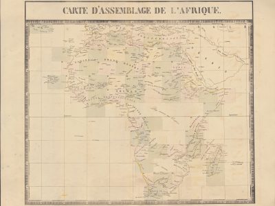
Descriptive notes: This map of Africa serves as index maps for the African section of the Atlas. Against the backdrop of a geographical grid, based on the Paris meridian for longitudes, and framed—by way of a rare aesthetic concession—by a small decorative border, the rectangles corresponding to the various sheets are numbered 1 to 57. In three cases, the numbering is duplicated: Sheet 1bis is dedicated to the Azores, 5bis to the Canary Islands, and 18bis to the Cape Verde archipelago. These rectangles are hand-watercolored in slightly different shades to help distinguish them.
In the central interior of Africa—where the Congo Free State would later be established—and in the southern interior, there are two blank areas: the first marked with the inscription “Pays inconnu aux Européens” (“Land unknown to Europeans”), the second more simply as “Pays inconnu” (“Unknown land”). It was typical of the time to omit uncertain information, leaving such areas blank. In other instances, uncertainty is shown through dashed lines—as is the case for many rivers in the Sahel, where the dashed line is sometimes accompanied by the name of the European explorer who proposed its course. No space, however, is given to indigenous knowledge. For example, a hypothetical Niger flowing southeast from Lake Chad is labeled “suivant Horneman” (“according to Horneman”) and passes just north of a western branch of the Nile, which is itself placed slightly north of the Ptolemaic Mountains of the Moon.
Bibliography
- Pase, Andrea, Emptying and Filling: Maps of Inland Africa, in Rossetto, Tania & Lo Presti, Laura (eds.), The Routledge Handbook of Cartographic Humanities, London-New york, Routeledge, 2024, pp. 235-245.
- Silvestre, Marguerite , “Philippe Vandermaelen, the Mercator of young Belgium”, Brussels Studies [Online], General collection, n. 106 (http://journals.openedition.org/brussels/1438)
- Wellens-De Donder, Liliane, "Le globe géant de Philippe Vandermaelen a l'Établissement géographique de Bruxelles", Der Globusfreund, n. 18/20 (may 1970), pp. 130-133 (https://www.jstor.org/stable/41626595?seq=1)
Reference websites
https://www.davidrumsey.com/maps990067-25177.html
https://static-prod.lib.princeton.edu/visual_materials/maps/websites/vandermaelen/home.htm
https://fr.wikipedia.org/wiki/Philippe_Vandermaelen