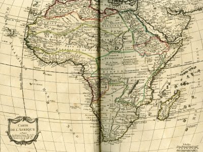
Carte de l’Afrique
Louis-Charles Desnos, Atlas élémentaire de la géographie contenant les quatres parties du monde, 1784
Title of the volume: Atlas élémentaire de la géographie contenant les quatres parties du monde, les empires, royaumes et républiques de l’Europe en vingt feuilles (Atlas élémentaire de la géographie contenant les quatres parties du monde, les empires, royaumes et républiques de l’Europe en vingt feuilles)
Date: 1784
Author: Louis-Charles Desnos (1725-1805)
Engraver: Pierre Bourgoin (18th century) (engraver)
Publisher and place of publication: Paris
Plate execution technique: Chalcography
Language: French
Location: Geography Library, Morbiato Collection, MORB.25
Notes on the volume: Louis-Charles Desnos was a French bookseller, publisher, geographer, and constructor of globes and spheres, serving for twenty years under King Christian VII of Denmark (1769-1789). He was the author of many geographical publications. He published the Atlas élémentaire de la géographie with the approval and privilege of King Louis XVI of France (1754 – 1792); the information reported derives from the research of members of the Royal Academy of Sciences. The volume opens with an introductory plate on astronomical geography, depicting in the center the mechanisms of eclipses (solar and lunar) and the different positions of the planets, surrounded by the cosmological models of Ptolemy (2nd century), Copernicus (1475), Tycho-Brahe (1546) and Descartes (1596), with attached descriptions and explanations; the next page presents five different types of globes with their relative description: they are the oblique armillary sphere, the celestial globe, the terrestrial globe, the right sphere and the parallel sphere. The following 20 plates are dedicated to the cartographic representation of the various continents, with a preponderant presence of European maps.
GEO-CARTOGRAPHIC DATA
Scale: Approximately 1:24,000,000
Graphic scale: Scales, Marine Leagues of France of 20 to the Degree; Common Leagues of 25 to the Degree.
Orientation: N at the top
Size: 44.5 x 36 cm (matrix imprint)
Descriptive notes and regional divisions: In the essential cartouche adorned with festoons at the bottom left, the title of the map and the responsibility indications relating to the engraver are reported: “In Paris. At Bourgoin Engraver Rue de la Harpe opposite the Passage des Jacobins next to the Caffè de Condè”. The relief is rendered using the “molehill” technique. The longitude is calculated on the meridian of Ferro Island. The map presents numoerous place names, not limited to the coasts alone (even the eastern ones particularly detailed), but investing also the interior of the continent, a sign of greater knowledge acquired.
Ten macro-regions are identified, highlighted by watercolored borders: “Barbary” in the north, south of which extend the “Sahara or Desert of Barbary”, then “Africa/Libya/Land of the Negroes” and, even further south, “Upper Guinea”; “Egypt” in the northeast, south of which we encounter the “Kingdom of Sennar or Nubia” and “Abyssinia”; “Ethiopia” in the center; southwest of the Equator is “Congo/Lower Guinea”, while the entire southern part of Africa is occupied by the vast “Kaffraria”. Each region in turn presents further territorial articulations. Regarding the Sahel, for example, in the Libya region there are among others the kingdoms of Mandinga, Casson, Cano, Zanfara, Buornou, Ghana; in Upper Guinea are the kingdom of Benin, Biafara, Juda and André, as well as the Ivory Coast, the Gold Coast and the “Grain Coast”; in the Ethiopia region there are the kingdoms of Medra, Courourfa and Mujac.
On the hydrographic level, of the great rivers, in addition to the Nile, the Senegal is present, of which a note explicates the source: “Lake Maberia from which the Senegal emerges”; the “Niger or Nile of the Negroes”, fed by the Gambarou river that originates from the mountains of the Kingdom of Isa, traces its characteristic arc near Tombut (Timbuktu) flowing eastward, crosses a first lake in the Kingdom of Ghana and flows into Lake Bournou, in the kingdom of the same name; the current Benin river, indicated by the name “Jamor or R. de los Camaranes”, instead flows into the Gulf of Guinea; further south is the Congo river; to the east is traced the Zambezi river that flows into the Mozambique Channel. The courses of other rivers are hypothetically outlined. Cities are identified by two different symbols: for capitals, the form of a stylized building is used, for other cities a white circle.
Bibliography
Pommier H., Perez M.-F. & Martin De Vesvrotte S. (2002). Dictionnaire des graveurs-éditeurs et marchands d’estampes à Lyon aux XVIIe et XVIIIe siècles et catalogue des pièces éditées. Lyon: Presses Universitaires de Lyon.
Withers C.W.J. (2004). Mapping the Niger, 1798–1832: Trust, Testimony and ‘Ocular Demonstration’ in the Late Enlightenment. Imago Mundi, 56/2: 170-193.
Reference websites
https://data.bnf.fr/fr/12402252/louis-charles_desnos/