Darfour et Kordofa
Philippe Vandermaelen, Atlas Universel de Géographie Physique, Politique, Statistique et Minéralogique, 1827
Title of the volume: Atlas Universal de Géographie Physique, Politique, Statistique et Minéralogique
Date: 1827
Author: Philippe Vandermaelen (Brussels, 1795 – Molenbeek, 1869)
Lithographer: Henry Ode
Publisher and place of edition: Ph. Vandermaelen, Bruxelles
Printing tecnique of the plates: hand-watercolored lithograph
Language: French
Location: Biblioteca di Geografia, CART.MORBIATO.52
Notes on the volume: The first edition of the Atlas Universel de Géographie Physique, Politique, Statistique et Minéralogique, sur l’echelle de 1/1641836 ou d’une ligne par 1900 toises, dresse par Ph. Vandermaelen, Membre de la Societe de Geographie de Paris, d’apres les meilleures cartes, observations astronomiques et voyages dans les divers Pays de la Terre, was published in 40 fascicles of 10 maps each, between 1825 and 1827. Author, and publisher, was the self-taught Belgian cartographer Philippe Vandermaelen, founder of the private cartographic establishment Établissement Cartographique de Bruxelles. He created something entirely new—indeed, this atlas holds several noteworthy distinctions. It was the first atlas to use the same scale — specifically the large scale of 1:1,641,836 — for all parts of the world. It includes the first large-scale maps of many territories recently explored by Europeans, and it was the first atlas produced using the new technique of lithography. Moreover, the maps, in conical projection, were designed to be ideally assembled into a three-dimensional globe with a diameter of about 7.75 meters. At least one copy of the globe was produced and displayed in the library of Vandermaelen’s Établissement Géographique.
The complete work, in folio format, is divided into six parts: the first dedicated to Europe; the second to Asia; the third to Africa; the fourth to North America; the fifth to South America; and the sixth to Oceania. The total number of maps is 737, plus 6 index maps. The Museum of Geography received as a donation from Armando Morbiato the unbound parts 2 (Asia), 3 (Africa), and 5 (South America). The Africa section consists of one general overview plate and 60 separate maps. Areas of the plates not occupied by cartographic elements are often enriched with descriptive, statistical, and historical notes.
GEO-CARTOGRAPHIC DATA
Scale: 1:1,641,836
Graphic scale: –
Orientation: North at the top
Dimensions: 56×47 cm
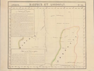
Descriptive notes: The map is characterized by a very limited amount of information. The two regions of Darfour and Kordofan, which give the map its title, are labeled in uppercase letters, while the Bayuda Desert (“Désert Bahi0uda”) is marked in smaller print. A dashed line highlighted in watercolor refers to a possible watercourse, identified with the name Taashye, which is likely based on reports by the Swiss explorer Johann Ludwig Burckhardt (“Burckh” appears in parentheses after the name; Burckhardt is a confirmed source for Vandermaelen, as he is cited elsewhere, including on this same map). Another unnamed dashed river is located in Kordofan.
Several place names are written in lowercase print along a broken line, which traces the route of the British explorer William George Browne (“Route de Brown en 1793 et 1796”).
Running from south to north, a mountain chain labeled “Tega et Wanna Chaine de Rochers” occupies the center of the map.
A “Volcan Koldagi Rüppel” could possibly refer to Jebel Marra. Notably, the journey to Sudan by the German Eduard Rüppell, almost contemporary with the map, is already used as a source.
Finally, the names of some indigenous peoples are indicated: “Arabes Cubbabeesh” and “Arabes Beni Gerar.”
The large empty space is filled by two text boxes describing the region and its inhabitants. These texts reflect a strong devaluation of the local population, heavily influenced by the deterministic prejudice common at the time against the peoples of hot climates.
Bibliography
- Pase, Andrea, Emptying and Filling: Maps of Inland Africa, in Rossetto, Tania & Lo Presti, Laura (eds.), The Routledge Handbook of Cartographic Humanities, London-New york, Routeledge, 2024, pp. 235-245.
- Silvestre, Marguerite , “Philippe Vandermaelen, the Mercator of young Belgium”, Brussels Studies [Online], General collection, n. 106 (http://journals.openedition.org/brussels/1438).
- Wellens-De Donder, Liliane, "Le globe géant de Philippe Vandermaelen a l'Établissement géographique de Bruxelles", Der Globusfreund, n. 18/20 (may 1970), pp. 130-133 (https://www.jstor.org/stable/41626595?seq=1).
Reference websites
https://www.davidrumsey.com/maps990067-25177.html
https://static-prod.lib.princeton.edu/visual_materials/maps/websites/vandermaelen/home.htm
https://fr.wikipedia.org/wiki/Philippe_Vandermaelen
https://www.britannica.com/biography/Eduard-Ruppell
https://www.britannica.com/biography/William-George-Browne
https://www.britannica.com/biography/Johann-Ludwig-Burckhardt