Donga
Philippe Vandermaelen, Atlas Universel de Géographie Physique, Politique, Statistique et Minéralogique, 1827
Title of the volume: Atlas général de Géographie Physique, Politique, Statistique et Minéralogique
Date: 1827
Author: Philippe Vandermaelen (Brussels, 1795 – Molenbeek, 1869)
Lithographer: Henry Ode
Publisher and place of publication: Ph. Vandermaelen, Brussels
Technique used for the plates: hand-coloured lithographs
Language: French
Location: Geography Library, Morbiato Collection, CART.MORBIATO.52
Notes on the volume: The first edition of the Atlas Universel de Géographie Physique, Politique, Statistique et Minéralogique, sur l’echelle de 1/1641836 ou d’une ligne par 1900 toises, dresse par Ph. Vandermaelen, Member of the Paris Geographical Society, based on the best maps, astronomical observations and travels in various countries around the world, was published in 40 instalments of 10 maps between 1825 and 1827. The author and publisher, the self-taught Belgian cartographer Philippe Vandermaelen, founder and driving force behind a cartographic establishment, the Établissement Cartographique de Bruxelles, achieved something totally new, and in fact there are numerous firsts that we can attribute to this atlas: it is the first to use the same scale, namely the large scale of 1:1,641,836, for all parts of the world; it contains the first large-scale maps of numerous territories recently explored by Europeans; it is the first atlas produced using the recent technique of lithography. In addition, the maps, in conical projection, are designed to be ideally assembled in a three-dimensional globe with a diameter of approximately 7.75 metres. At least one example of the globe was made and displayed in the library of Vandermaelen’s Etablissement Géographique.
The complete work, in folio format, consists of six parts: the first dedicated to Europe; the second to Asia; the third to Africa; the fourth to North America; the fifth to South America; and the sixth to Oceania, for a total of 373 maps and six overviews. The Geography Museum received parts 2 (Asia), 3 (Africa) and 5 (South America), unbound, as a gift from Armando Morbiato. The part relating to Africa consists of an overview table and 60 loose maps. The parts of the tables without cartographic features are often enriched with descriptive, statistical and historical notes.
GEOGRAPHICAL DATA
Scale: 1: 1,641,836
Graphic scale: –
Orientation: N at top
Dimensions: 56×47 cm
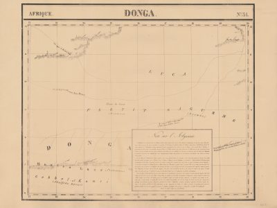
Descriptive notes: The map contains very limited information, much of which is accurately sourced: from north to south, we find the regional names “Luca”, “Fertit” and “Sagurme” (for the latter two, William George Browne is cited as the source in brackets) and, in larger letters, “Donga”. In the centre of the sheet, copper mines (‘Mines de cuivre’) are indicated in general terms. Mountain ranges, rendered using hatching, are located at the four corners of the sheet: the one in the north-west does not show any place names, but it is noted that, according to Browne, the Misselad caravan route passed through it; the north-eastern one is identified as “Mont Deir et Touggala”, where the Niger and Western Nile rivers converge (also referred to as “Bahar-el-Abiad” and “Fleuve Blanc”, meaning White River). According to the author of the map, the mountains in the south-western area could correspond to Ptolemy’s Montes Lunae, mentioned in brackets, or to the Gebbel-al-Komri chain mentioned by Abū l-Fidā and al-Idrīsī, also mentioned in brackets. Finally, the mountains located in the south-east reflect a hypothesis by the German geographer Carl Ritter: “Suivant l’opinion de Mr. Ritter il existe ici une chaine de Montagnes qui lie les Monts de la Lune au Plateau de Narea”. Returning to the two rivers mentioned above, the map explains that the course of the Niger is traced according to the sources Hornemann, Jackson and Barrow, while that of the Western Nile is based on Ptolemy, Abū l-Fidā, al-Idrīsī and Browne. The remaining large empty space is filled with a 21-line italic text, framed and entitled “Notes sur l’Abyssinie”, which does not end, but refers to table 34 of the work for the conclusion.
Bibliography
- Pase, Andrea, Emptying and Filling: Maps of Inland Africa, in Rossetto, Tania & Lo Presti, Laura (eds.), The Routledge Handbook of Cartographic Humanities, London-New york, Routeledge, 2024, pp. 235-245.
- Silvestre, Marguerite , “Philippe Vandermaelen, the Mercator of young Belgium”, Brussels Studies [Online], General collection, n. 106 (http://journals.openedition.org/brussels/1438).
- Wellens-De Donder, Liliane, "Le globe géant de Philippe Vandermaelen a l'Établissement géographique de Bruxelles", Der Globusfreund, n. 18/20 (maggio 1970), pp. 130-133 (https://www.jstor.org/stable/41626595?seq=1).