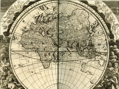
Facies altera hemispherii terrestris
Johann Zahn, Specula Physico-Mathematico-Historica, 1696
Title of the volume: Specula Physico-Mathematico-Historica
Date: 1696
Author: Johann Zahn (1631–1707)
Printers: Johann Christoph Lochner, Andreas Knorz
Publisher and place of publication: Nuremberg
Plate execution tecnique: Chalcography
Language: Latin
Location: Geography Library, Morbiato Collection, MORB.16.
Notes on the volume: First edition of this extensive two-volume compendium of natural history, superbly illustrated. The author, Johann Zahn (1641–1707), a canon of the Premonstratensian monastery of Oberzell near Würzburg, was also a renowned experimenter and illustrator of optical machines. The work consists of three volumes: the first is dedicated to the Sky (astronomy, astrology, meteorology), the second to the Earth (geology, mineralogy, botany, zoology, and geography), and the third to Humans (anatomy and cognitive processes). Among the beautiful illustrations are plates previously published by other authors, often cited as sources in the text. These include the celestial maps of the famous Polish astronomer Johannes Hevelius (1611–1687), depictions of the Sun and Moon by the German astronomer and artist Georg Christoph Eimmart (1638–1705), and terrestrial sections showing the circulation systems of fire and water by Athanasius Kircher (1602–1680), whose Mundus Subterraneus is also referenced in the map of ocean currents. Other cartographic references can be found in the works of Joan Blaeu (1596–1673).
GEO-CARTOGRAPHIC DATA
Scale: approx. 1:6,400,000
Graphic scale: –
Orientation: North at the top
Size: 42 × 36 cm (plate impression); diameter 34 cm
Descriptive notes and regional divisions: The map, as noted in the footer, is referenced in the text of the second volume, page 6. In the two lower corners are allegorical representations of Autumn and Winter, while the upper corners feature zodiac signs: Libra, Scorpio, and Sagittarius on the left; Capricorn, Aquarius, and Pisces on the right. Along the upper semicircle runs a simple, thin cartouche bearing the title. The circumference and diameter are marked in 10° intervals; both the tropics and polar circles are shown among the parallels. In addition to the Equator, the path of the ecliptic is illustrated. To the east, “Hollandia Nova”—that is, Australia—is depicted with uncertain and incomplete boundaries. The European discovery of Australia began in 1605–06 with the exploratory voyages of Dutchman Willem Janszoon (1570–1630), later continued by compatriot Abel Tasman (1603–1659), who was the first to reach New Zealand and Tasmania (1642–44), producing numerous maps later compiled by Joan Blaeu in his Nova et Accuratissima Totius Terrarum Orbis Tabula (1662–66), which is undoubtedly Zahn’s main source. Complete knowledge of Australia’s geography would only come in the last quarter of the 18th century through the explorations of British cartographers James Cook (1728–1779) and Matthew Flinders (1774–1814).
The African continent appears rich in place names and hydrographic details, while orographic information is entirely absent. As for hydrography, the Ptolemaic model persists, with two lakes identified as the sources of the Nile located south of the Equator. The central-western part of the Sahel is crossed by the usual single river erroneously combining the Niger and Senegal, labeled as “Niger flu[men]” in its middle course and “Senega” near its mouth; further east, its course begins at the “Borno” lake, roughly corresponding to Lake Chad. Cities are identified with small white circles outlined in black, accompanied by italicized place names. Region names are in uppercase, such as “Barbaria,” “Numidia,” Guinea, “Libya Interior Sarra,” “Abissinorum,” and “Biafara,” along with major kingdoms like Benin, Zanfara, Nubia, Medra, and Gaoga.
Bibliography
Jutzi A. et al. (1985). Intramuralia. Huntington Library Quarterly, 48/2: 200-208..
Kanas N. (2007). Star Maps. New York, Springer.