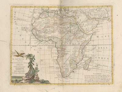
L’Africa divisa ne’ suoi principali Stati, di nuova projezione
Antonio Zatta, Atlante novissimo, illustrato ed accresciuto sulle osservazioni e scoperte fatte di più celebri e più recenti geografi, 1778-1785
Title of the volume: Atlante novissimo, illustrato ed accresciuto sulle osservazioni e scoperte fatte di più celebri e più recenti geografi (Newest Atlas, illustrated and expanded based on observations and discoveries made by the most celebrated and recent geographers ) [4 vols.]
Date: 1778-1785
Author: Antonio Zatta (1756-1797)
Engraver: Giuliano Zuliani (1730-1814)
Publisher and place of publication: Antonio Zatta, Venice
Plate execution technique: Chalcography with hand watercoloring
Language: Italian
Location: Geography Library, ATL. PRE.9.1-4
Notes on the volume: The atlas, published in Venice, incorporates new discoveries produced during a historical phase characterized by a proliferation of exploratory voyages extended on a global scale. The image of the world it presents is changing, much more precise and detailed than in the past. The first edition of the atlas, published between 1778 and 1785, includes 4 volumes, obtained the support of the Venetian Senate for publication, and enjoyed great editorial success. Zatta represents the most prolific Venetian publisher of the 18th century, and his publications had a very wide circulation. The copy present at the Geography Library of the University of Padua was acquired by the Geography Department in 1887, when prof. Giovanni Marinelli was its director.
GEO-CARTOGRAPHIC DATA
Scale: Approximately 1:31,000,000
Graphic scale: –
Orientation: North at the top
Size: 299 x 396 cm (matrix imprint)
Descriptive notes and regional divisions: The map is included in the 4th volume of the work. At the bottom left, a cartouche bordered by a bird in flight, various types of trees, a panther placed on a large boulder, and the sea bears the inscription “L’AFRICA divisa NE’ SUOI PRINCIPALI STATI, Di Nuova Projezione, VENEZIA 1776, Presso Antonio Zatta, Con Privilegio dell’ Eccmo Senato” (“AFRICA divided INTO ITS PRINCIPAL STATES, In a New Projection, VENICE 1776, By Antonio Zatta, With Privilege of the Most Excellent Senate”). At the bottom right, another inscription reads: “Avvertimento. La Posizione di questa carta essendo in molte parti diversa dalle altre finora uscite, e sopra tutto dalla più recente del Sr. Janvier, si avverte che tale varietà non proviene dal nostro arbitrio ma dalle ultime osservazioni dell’Accademia Francese, a cui si uniformano le più moderne Carte particolari dell’Africa” (“Notice. The Position of this map being in many parts different from others published so far, and above all from the most recent one by Mr. Janvier, it is noted that such variety does not come from our discretion but from the latest observations of the French Academy, to which the most modern particular Maps of Africa conform”). Outside the frame, we find the responsibility indications: on the left “Z.Zuliani engraved” while on the right “Ab. V. Formaleoni wrote”. As the title and Notice report, although the map takes various aspects from the one present in the Atlas universel dressé sur les meilleures cartes modernes (1776) by Santini, created by J. Janvier, it differs from it in the use of a new projection.
The African continent appears divided into six macro-regions: “Barbary” in the north, “Egypt” in the northeast, “Nigritia” under Barbary, “Guinea” in the west, “Ethiopia” in the center, and finally, in the south, “Kaffraria”; these in turn present further detailed subdivisions. The main cities are highlighted by a stylized element reminiscent of the image of the sun. The reliefs are rendered through orographic hatching with lines following the slopes.
The main subdivisions that affect the Sahel, underlined by watercolored borders, are, starting from the East: Guinea, Nigritia, the upper part of Ethiopia where the Mountains of the Moon are located, Nubia, Turkish Nubia (connected to the Ottoman advancement of the time) and part of Abyssinia. Guinea, whose borders are green, is further subdivided into: Coast of Sierra Leone, Grain Coast, Teeth (or Ivory) Coast, Gold Coast, Adra Coast, Benin Coast, Kingdom of Biafara and Kingdom of Calabar. Nigritia, with pink borders, also sees the presence of the kingdoms of Mandinga, Tombut, Agade and Kagua. The main cities indicated by the stylized sun symbol are: Benin in Guinea, Agades in Nigritia, Dungola in Nubia and Guender in Abyssinia. Regarding hydrography, the Senegal River originates south of the “Negrita Swamp”, a lake identified by the map as the source of the Niger, and flows westward receiving the waters of numerous tributaries. The Niger, on the other hand, flows eastward with its characteristic arc shape in the Tomboctu area and ends by bifurcating into two lakes: to the west that of Regebil and to the east that of Semegoonda; the Gazelle River, located northeast of “Nigritia” has its origins in Lake Bournou and shortly after bifurcates, continuing to flow south towards Ethiopia and, to the east, reaching Lake Gaoga to then continue in Nubia, where the kingdom of Fungi is indicated.”
Bibliography
Cusimano G. & D’Agostino G., eds. (1986). L’Africa ritrovata. Antiche carte geografiche dal XVI al XIX secolo. Palermo, Quaderni del “Servizio Museografico” della Facoltà di Lettere e Filosofia dell’Università di Palermo: 98.
Vladimiro V. (1997). Late Eighteenth- and Early Nineteenth-Century Italian Atlases. In: John A. Wolter J.A. & Grim R.E., eds., Images of the World. Washington, Library of Congress: 257-300.
Reference websites
Phaidra (Permanent Hosting, Archiving and Indexing of Digital Resources and Assets), piattaforma del Sistema Bibliotecario di Ateneo per l’archiviazione a lungo termine di oggetti e collezioni digitali: https://phaidra.cab.unipd.it/detail/o:269367