L’Africa divisa nelle sue principali regioni
Francesco Costantino Marmocchi, Atlante di geografia universale, 1838
Title of the volume: Atlante di geografia universale (Atlas of Universal Geography)
Date: 1838
Author: Francesco Costantino Marmocchi (1805–1858)
Publisher and place of publication: Vincenzo Batelli e figli, Florence
Plate execution technique: Copperplate engraving with hand coloring
Language: Italian
Location: Geography Library, ATL.ANT.53
Notes on the volume: Atlante di geografia universale: preceduto da un vocabolario de’ nomi tecnici della geografia, corredato da specchi statistici delle divisioni politiche della terra, ed arricchito d’illustrazioni e di una bilancia politica del Globo per servire al corso di geografia universale is a work by Francesco Costantino Marmocchi (Poggibonsi 1805 – Genoa 1858). It contains 67 plates depicting geographical (numbered I–LVIII), astronomical, orographic, and hydrographic maps. The author, a respected geographer and committed Mazzinian, participated in the uprisings of 1831, the year he was imprisoned. After exile in Naples and a period in Rome, he became a Deputy in the Tuscan Parliament in 1848, later serving as Secretary of the Interior in the Guerrazzi government.
Marmocchi was the author of important works in statistical-descriptive geography, passionately and competently dedicating himself to reports on explorations and travels. His approach was notably advanced for the time, viewing geography “as the science of territory, but also as a comparative description of the socio-economic conditions and organizational modes of states” (Landucci, 1999).
The atlas, when closed, measures 11.5 x 17 cm, while the internal plates vary in pagination. The text is structured into four chapters: Cosmography (14 maps); Physical Geography (15 maps); History of Geography from Biblical and Homeric Times to the Discovery of the New World (9 maps); and Statistical Geography: Political Balance of the Globe and a Statistical Overview of Several European Kingdoms (30 maps, including hand-colored flags of various countries). The whole is preceded by a useful glossary on physical geography and related terms.
The atlas includes political, physical, and economic maps of all world regions, as well as more detailed regional maps. Written text and tables provide morphological, economic, political, statistical, and historical-geographical information alongside the maps. The text was widely used in educational institutions of the time, often supporting Marmocchi’s other work, Corso di Geografia sviluppato in cento lezioni (Batelli publisher, Florence, 1838), whose accuracy and completeness made it a valuable tool for 19th-century scholars and explorers, also influencing other contemporary cartographers and geographers. In general, Marmocchi is recognized for his fundamental role in spreading geographical knowledge in the Italian-speaking world.
GEO-CARTOGRAPHIC DATA
Scale:
Graphic scale: Common Italian miles of 60 per degree – Common French leagues of 25 per degree – Schaene of the Thebaid, 11/9 per degree
Orientation: North at the top
Dimensions: 57 x 51.5 cm
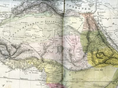
Descriptive notes: Plate number 36 encompasses the entire African continent, though only the detail of the central-northern part is reproduced here. Various color fields seem to indicate a rough territorial division, but no legend is provided. The meaning of the long dashed lines that cross the map is also unclear; only occasionally do they seem to outline territorial units (as in the case of “DARFUR”). To indicate the region of the “Great Desert of Sahara,” a black stippling is used, which halts at villages or supposed oases.
The great desert appears subdivided into smaller areas, named from west to east: “Desert of Azgar,” “Desert of Tegazza,” “Desert of Azarad,” “Desert of Jazr,” and “Desert of Lemla.” To the southwest, where the stippling ends, the fishbone-like depiction of mountain chains begins in the region of “Senegambia,” “Bambara,” and “Mandinga.” In the latter area, the sources of the three major rivers of western “Negroland” are identifiable: “Source of the Gambia,” “Source of the Senegal,” and “Source of the Niger.” Near the latter, no source lake is indicated—unlike in many other maps examined. The course of the “Niger or Gioliba” is, in general, more accurate than in previous representations: after reaching “TOMBUCTU,” the river continues eastward for a short stretch and then turns south, emptying into the “Gulf of Guinea.
Around “Lake Tsciad” are: to the northwest, the “Fertile Country” indicating the oasis of “Agades,” an urban center and commercial hub along the course of the “Torrente di Mezzeran”; to the west, the depiction of the Yobe tributary of Lake Chad, labeled “Yue F.,” flowing through the region of “Guber or Lamlem” and reaching the city of Melli, whose toponymy refers to information reported by Leo Africanus in Description of Africa and of the Notable Things Therein, published in Venice in 1550 and already featured in 1564 in the cartographic works of Giacomo Gastaldi. To the south appears the “F. Sciary,” the main tributary of Lake Chad, which flows southwest. Despite its inaccurate direction and flow, it demonstrates Marmocchi’s attention to the accounts of explorers Hugh Clapperton and Dixon Denham, who in 1823 reached Lake Chad and its major outflow, being the first Europeans to see and map it in their reports published the following year.
Northeast of the great lake is “BORNOU,” also mentioned by Leo Africanus, a central African kingdom very active in Saharan trade routes. The region of the Bornou kingdom lies between the “Desert of Ghet” and the “Desert of Bournou,” itself between the rivers “F. Gazel or Antelope” and “Bahr el Fittre.” These rivers appear to originate from a lake, likely Lake Fittre, on whose shores the village of “Kanga” is placed. It is fed by a long river apparently rising from the Ethiopian plateau, labeled “Bahi Misselad the Gir di Pholemeo.” Notably, this region is located too far northeast of Lake Chad compared to earlier and later representations.
East of Lake Semegonda, beyond Darfur and Kordofan, lies the most information-dense area of the entire map: the source region of the Nile River, filled with orographic markings and toponyms in various fonts and sizes. According to this map, “Lake Dembea,” surrounded by a mountain range that feeds it, gives rise from its southern shore to the “Nile F.,” which after flowing south for a short distance, winds through the mountains and begins its journey toward the Mediterranean. In its upper stretch, it does not even seem to be the region’s largest river, but gradually, as many tributaries join, its volume increases significantly.
Bibliography
ROMAGNOLI, Luca. La percezione del mondo di Francesco Costantino Marmocchi, geografo preunitario. Semestrale di studi e ricerche di geografia, 1998.
PALLINI, Rosanna. Francesco Costantino Marmocchi (1805-1858). Consiglio regionale della Toscana, 2011.
Reference websites
https://www.treccani.it/enciclopedia/francesco-costantino-marmocchi_(Dizionario-Biografico)/
https://exhibits.stanford.edu/ruderman/catalog/hb210gy9442
https://cartiglio.it/product.php?l=it&id=5485#