Title of the volume: L’Usage des globes célestes et terrestres, et des sphères suivant les différents systèmes du monde. Précédé d’un traité de cosmographie… Par le sieur N. Bion… (The Use of Celestial and Terrestrial Globes, and of Spheres According to the Different World Systems. Preceded by a Treatise on Cosmography… By Mr. N. Bion…)
Date: 1751
Author: Nicolas Bion (1652?-1733)
Printer: Jean Luc Nyon
Publisher and place of publication: Jacques Guerin, Paris
Plate execution technique: Chalcography
Language: French
Location: Geography Library, Morbiato Collection, MORB.20
Notes on the volume: The first professional mention of the French engineer Nicolas Bion dates back to 1690, when he is cited in a page of the Journal des Sçavans, Europe’s first scientific journal. In his career he became a highly successful maker of mathematical-astronomical instruments: between 1708 and 1712, he was appointed by Louis XIV as “Ingénieur du Roi pour les instruments de mathématique”. In 1694, he constructed his first globe, using copperplates acquired from Pierre Courtin; the latter was also the author of theoretical works, such as the Traité de Cosmographie which Bion incorporated in 1699, albeit without citation, into his L’usage des globes célestes et terrestres et des sphères. This highly successful handbook, as evidenced by the six French editions that appeared by 1751, and numerous translations into German and English, responds to a widespread demand for knowledge about the practical use of globes, which were by then widely diffused among the wealthy classes. In the preface, the author, in addition to explaining his choice to dedicate a treatise to the instruments of mathematical geography, reveals that he received help from the most skilled contemporary geographers and astronomers. Among the credited sources, we recall Giovanni Domenico Cassini and Philippe de la Hire for the passages concerning eclipses and planet dimensions, both members of the Acadèmie Royale des Sciences and thus ensuring prestige and scientific value to his work.
GEO-CARTOGRAPHIC DATA
Scale: Approximately 1:53,000,000
Graphic scale: Echelles de Lieues communes de France
Orientation: North at the top
Size: 20 x 16 cm
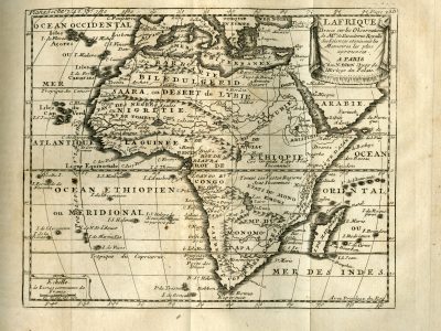
Descriptive notes and regional divisions: In the upper right, a simple drapery frames the cartouche “LAFRIQUE. Dressé sur les Observations de M.rs de L’academie Royalle des Sciences et suivant les Memoires les plus aprouvées. A PARIS chez N. Bion Quay de l’Horloge du Palais” (errors are in the original text), while at the bottom right appears the privilege granted by the French crown “Avec privilege du Roy”. The map festures numerous toponyms, particularly concentrated along the coasts; cities, without distinctions, are marked by a white circle. Relief is rendered using the “molehill” system. The sources of the Nile are not located, as per Ptolemaic tradition, in the Mountains of the Moon present in the southern part of Africa, but in the region of Abyssinia. Nine macro-regions are identified: “Barbarie” and “Biledulgerid” in the north, “Saara, ou desert de Lybie” and “Nigritie” (also “Pays des negres”) just to the south, “Guinee”, “Egipt”, “Nubie” and “Ethiopie” north of the Equator, and, to the south, “Emp. de Monomotapa” (attested in southeastern Africa from 1430 to 1766); also in the south of the continent is “Cafrerie ou coste de Cafres”, whose extension compared to other previous representations of the same region appears reduced due to the presence of the Monomotapa Empire. Straddling the Equator, in the wide eastern area between “Ethiopie” and “Etas du Monoemugi”, two indications reiterate that these are totally unknown regions.
In the Sahel, the coasts of Sierra Leone, of Teeth, of Gold, and the “Roy de Biafra” follow one another in Guinea; moving into “Nigritia”, framed by mountain ranges to the north and south, we find the Kingdom of Tombut and that of Medra. The area appears crossed only by the Niger River, whose origin is placed in “Lac Niger”; flowing from east to west, it creates, about halfway through its course, a lake characterized by the presence of an island; it finally flows into the “Mer Atlantique” but only after a secondary branch called “Senega” has detached from it to reach the sea a little further north.
Bibliography
Casas R., Vaquero J.M. e Vazquez M. (2006). Solar Rotation in the 17th century. Solar Physics, 234:379-392.
Daumas M. (1948). Les constructeurs français d’appareils scientifiques au XVIII siècle. Thalès, 5: 50–84.
Engel P. (2009). The importance of historical source texts as proofs of globe making, presented at the example of the conservation treatment of the “schrester-jüttner-globe” of the ‘austrian national library. Globe Studies, 55/56: 165–181.
Pelletier M. (1987). From the luxury item to the current consumption product development of french globe publishing in 18th-19th centuries / vom luxusgegenstand zum konsumartikel – Entwicklung der französischen Globusproduktion im 18. u. 19. Jhdt. Der Globusfreund, 35/37:131–144.
Turner A. (2014). Nicolas Bion, globe-maker, instrument-maker, author and business-man. Globe Studies, 59/60: 198–218.