Title of the volume: Liber Chronicarum (Nuremberg Chronicles)
Date: 1493
Author: Hartmann Schedel (1440-1514)
Engravers: Michael Wohlgemut (1434-1519) and Wilhelm Pleydenwurff (ca. 1458-1494)
Printer: Anton Koberger (ca. 1445-1513)
Publisher and Place of Publication: Anton Koberger, Nuremberg
Plate execution tecnique: Woodcut
Language: Latin
Location: Geography Library, Morbiato Collection, MORB.1
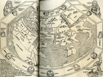
Notes on the Volume: The Liber Chronicarum, published in the Latin edition on July 12, 1493, is one of the most richly illustrated books of the 15th century. It contains over 1,800 woodcuts created in the workshop of Michael Wohlgemut (1434-1519) and his stepson Wilhelm Pleydenwurff. The work is a chronicle in six books recounting major events from the creation of the world to the author’s time, followed by a seventh book dedicated to the end of times, which in turn is followed by a geographical section. The book also includes, for the first time, numerous city views, intended to provide the reader with a visual reference—sometimes familiar—to help them place and remember the reported information. The volume also contains two maps (a world map and a map of Central Europe) attributed to the humanist Hieronymus Münzer (1437-1508).
GEO-CARTOGRAPHIC DATA
Scale: –
Graphic Scale: –
Orientation: North at the top
Size: 43.6 x 54.5 cm
Descriptive Notes: Among the over 1,800 woodcuts, this famous representation of the Earth is likely the work of the humanist Hieronymus Münzer and remains based on a Ptolemaic conception. The European continent lacks Scandinavia, while in the East, Asia does not include the Far East. In the South, Africa is reduced to its northern part and extends as a narrow landmass towards the easternmost part of Asia, connecting to it and enclosing the Indian Ocean as an inland sea. The world map is surrounded by personifications of the winds and supported by the biblical figures of Ham, Shem, and Japheth, the three sons of Noah who repopulated the planet after the Great Flood.
In the African continent, several regions are highlighted: Egypt (not clearly visible in the reproduction), Carthage—located just west of the Nile—followed by Mauritania, and further south, Tunis. Even farther south lies Affrica (sic), roughly corresponding to the Sahara region. A large river, collecting waters from various tributaries, flows into the western coast and separates Affrica from Ethiopia to the south. The continent’s southernmost section is labeled Maritima Ethiopia, which, in its easternmost part, contains the Mountains of the Moon (unnamed on the map), the source of the western branch of Nili Flum? (the question mark appears in the original) and three tributaries of its eastern branch. Both branches feed into a lake, following the Ptolemaic model. East of the Nile’s sources lies Ethiopia interior (not visible in the reproduction). The northern course of the Nile is flanked by a long mountain range, depicted, like all the map’s topography, using the so-called “molehill” technique. The left side of the reproduction is missing, where some of the monstrous inhabitants of the unexplored regions of the Earth would have been depicted.
Bibliography
Huseman B.W., ed. (2021). Searching for Africa. The map Collection of Dr. Jack Franke. Arlington, University of Texas at Arlington Libraries.
Mangani G. (2005). Vedute di città per pregare sul modo antico di pensare attraverso i luoghi. Geostorie. Bollettino e Notiziario del Centro Italiano per gli Studi Storico-Geografici, 13/2: 125-138.
Meurer P.H. (2007). Cartography in the German Lands, 1450–1650. In: Woodward D., a cura di, History of Cartography. Vol. 3. Chicago, The University of Chicago Press Home: 1172-1245
Patkus R. (2014). The Printing of the Nuremberg Chronicle: Background, Production, Legacy, in Never Before Has Your Like Been Printed: The Nuremberg Chronicle of 1493. Poughkeepsie (New York), Vassar College Library.
Sottili A. (1996). 500 Jahre Schedelsche Weltchronik. Akten des internationalen Symposions vom 23/24. April in Nürnberg. Aevum, 70/2: 412-414.
Reference websites
Record from the online catalog of the Barry Lawrence Ruderman Map Collection at Stanford University: https://exhibits.stanford.edu/ruderman/catalog/sp980tb2890
Map record curated by the Morse Library of Beloit College (Wisconsin): https://digicoll.library.wisc.edu/cgi/t/text/text-idx?c=nur;cc=nur;view=text;idno=nur.001.0004;rgn=div2;node=nur.001.0004%3A4.7