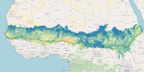
8- Convergence of Evidence map with nine land change issues
Convergence of Evidence (CoE) is an approach developed to analyze land degradation not through a single indicator, but by integrating multiple signals of environmental and human-induced stress. The core idea is that the co-occurrence of several critical factors—such as erosion, population pressure, productivity loss, and land use change—provides a more robust indication of ongoing or potential degradation.
The map shows that:
-
The areas with the highest convergence of degradation factors are located in the south, where human activities are more intense and agriculture is predominant.
-
The north appears more stable but is subject to chronic risks of desertification, despite lower anthropogenic pressure.
The approach enables precise mapping of degradation hotspots, offering a valuable tool for environmental restoration planning and monitoring of the Sustainable Development Goals (particularly SDG 15.3.1).
CoE allows us to address the complexity of land degradation in the Sahel in an integrated way, moving beyond reductionist views and supporting more informed and effective land management strategies.