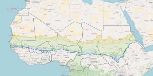
4- The core of the Sahel, the liminal Sahel and the buffer zone
The map presents an internal subdivision of the Sahel, based on two isohyets: 150 mm/year during the driest five-year period in the North and 850 mm/year during the wettest five-year period in the South. In this way, we identify three distinct zones: the core of the Sahel (between the two isohyets just described) or the area that is always Sahel, both in drought phases and in wetter phases; the liminal Sahel, between 150 mm/year in drought conditions and 150 mm/year in wet conditions, which is active only during the wetter phases; and finally, the Sahelian buffer zone, between 850 mm/year in wet conditions and 850 mm/year in dry conditions, which is the area where the Sahel recedes during drought conditions and where it has different and more favourable pluviometric conditions.