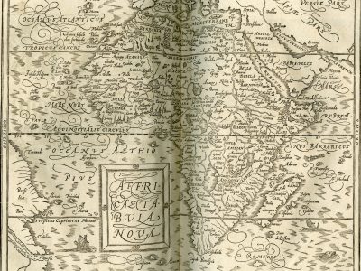
Affricae tabula nova
Sebastian Münster, Cosmographey, das ist Beschreibung aller Länder, Herrschaften und fürnemesten Stetten des gantzen Erdbodens, 1588 (1614)
Title of the volume: Cosmographey, das ist Beschreibung aller Länder, Herrschaften und fürnemesten Stetten des gantzen Erdbodens: sampt ihren Gelegenheiten, Eygenschaften, Religion, Gebräuchen, Geschichten und Handtierungen [et]c. Erstlich durch Herrn Sebastian Munster (Cosmography, that is Description of all Countries, Dominions and Principal Cities of the Whole Earth: along with their Locations, Properties, Religion, Customs, Stories and Trades etc. First by Mr. Sebastian Munster).
Date: 1614
Author: Sebastian Münster (1488-1552)
Publisher and place of publication: Sebastian Henricpetri (1546-1627), Basel
Plate execution tecnique: woodcut
Language: German
Location: Geography Library, Morbiato Collection MORB.5
Notes on the volume: The humanist, cosmographer, and geographer Sebastian Münster, who was also a professor of Hebrew at the University of Basel, published his Cosmographey in German in 1544, after 18 years of work. Aimed at an educated yet broad audience, the book aspires to provide a comprehensive description of the known world, paying close attention to both the course of human history and to botanical, zoological, and ethnographic data. Visual content also plays a crucial role, including maps, views, portraits, and more. The text and illustrations were continually updated by the author until the 1550 edition, which is considered the work’s pinnacle. It was among the most widely read and influential works of its time, as evidenced by more than 40 known editions published up to 1628, in at least four different languages (Latin, French, Italian, and Czech). The work is divided into six books, each focusing on a specific subject: the creation of the world and its divisions (Book I), Western Europe (Book II), Central Europe (Book III), Eastern Europe (Book IV), Asia and the Americas (Book V); Book VI is entirely devoted to Africa. The copy held at the Museum of Geography features an original “German-style” binding in pigskin on wooden boards, with decorations of concentric frames, floral motifs, palmettes, and various plaques containing portraits of German historians.
GEO-CARTOGRAPHIC DATA
Scale: approx. 1:25,000,000
Graphic scale: –
Orientation: N at the top
Size: 35 x 30.5 cm
Descriptive notes: On the left, in the Oceanus Aethiopus, a simple framed cartouche, discreetly decorated with four flowers, hosts the title of the map: “Affricae tabula nova”. This is the general map of Africa introduced in the editions of the Cosmographey from 1588, which corrects and updates the one in use since 1544. Like several other maps introduced that year, it is directly derived from Abraham Ortelius’s Theatrum Orbis Terrarum. This version would remain in use until 1628. On the left side, a portion of the Brazilian coast is depicted, albeit with limited geographical detail. The map includes numerous place names identifying cities, rivers, and lakes. The orography, depicted using the “molehill” technique, is especially dense and serves a largely decorative purpose. Most cities are indicated by a white circle; only Cotla and Damut, immediately south of the Equator, are given the symbol of a stylized building. As was typical of the period, the oceans are enlivened with sea monsters and ships. Notably, the woodcut technique employed in this plate is pushed to its limits in terms of line precision and detail, effectively imitating the finesse of copper engraving, which had by then become the dominant medium in cartography.
The regional subdivisions of the African continent are depicted in considerable detail. In the Sahel area, we find Libya, the Kingdom of Gago, the Kingdom of Melli, Guinea, and the kingdoms of Zanfara, Amazen, and Medra. The hydrography features the major Niger River, shown originating from an unnamed lake north of the Equator. It flows northward, disappearing underground for 60 miles in the region of Amazen (Hic Niger fl[umen] per 60 Mill[ia] j[ecta] sub Terram condit), before resurfacing to the north in Lake Bornu.From there, it turns westward, receiving numerous tributaries and passing through Lake Gruber, ultimately emptying into the Atlantic Ocean— labeled here as Mare Nort —in a delta with multiple branches.
Bibliography
Betz R.L (2007). The Mapping of Africa. A Cartobibliography of Printed Maps of the African Continent to 1700. Utrecht, Hes & de Graaf.
Mangani G. (2005). Vedute di città per pregare sul modo antico di pensare attraverso i luoghi. Geostorie. Bollettino e Notiziario del Centro Italiano per gli Studi Storico-Geografici, 13/2: 125-138.
Cusimano G. & D’Agostino G., eds. (1986). L’Africa ritrovata. Antiche carte geografiche dal XVI al XIX secolo. Palermo, Quaderni del “Servizio Museografico” della Facoltà di Lettere e Filosofia dell’Università di Palermo: 62-63.
Patkus R. (2014). The Printing of the Nuremberg Chronicle: Background, Production, Legacy, in Never Before Has Your Like Been Printed: The Nuremberg Chronicle of 1493. Poughkeepsie (New York), Vassar College Library.
Meurer P.H. (2007). Cartography in the German Lands, 1450–1650. In: Woodward D., ed., The History of Cartography. Vol. 3. Chicago, The University of Chicago Press: 1172-1245.
Meurer P.H. (1993). Der neue Kartensatz von 1588 in der Kosmographie Sebastian Münsters. Cartographica Helvetica: Fachzeitschrift für Kartengeschichte, 7: 11-20.