Title of the volume: Relationi universali di Giovanni Botero benese. Divise in quattro parti. Arichitte di molte cose rare, e memorabili, con l’ultima mano dell’auttore. Accresciutovi varie osservationi di Girolamo Brusoni sopra le medesime relationi universali, con le notitie degli affari più rilevanti di stato, e di religione di questo secolo. Et aggiuntovi la ragione di stato del medesimo Botero
Date: 1671
Author: Giovanni Botero (1544–1617)
Printers: Girolamo Brusoni (c. 1614–1686), Giovanni Antonio Bertano (active 1570–1599)
Publisher and place of publication: Bertani, Venice
Plate execution tecnique: chalcography
Language: Italian
Location: Geography Library, Morbiato Collection, MORB.13
Notes on the volume: The Relationi Universali by Giovanni Botero were published in several parts between 1591 and 1596; in the following century, the work saw around one hundred editions and numerous translations. Although initially conceived as a statistical analysis of the global spread of Christianity, it gradually expanded to include information on the physical, demographic, economic, military, and political characteristics of all the world’s states, eventually establishing itself as a true treatise on political geography. The work is divided into four sections: the first provides a general description of the four continents (Europe, Asia, Africa, and America), with particular — though not exclusive — attention to commercial, economic, and social aspects; the second examines, from a statistical perspective, the reasons behind the greatness of major states; the third addresses the distribution of religions among the world’s peoples; the fourth explores the religions of the New World and the challenges of evangelizing its inhabitants. The edition under examination also includes the work that chiefly earned the Jesuit Botero his renown: La ragion di Stato, first published in 1589.
GEO-CARTOGRAPHIC DATA
Scale: 1:42,000,000
Graphic scale: –
Orientation: North at the top
Dimensions: 17.5 × 24.5 cm
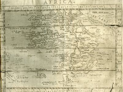
Descriptive notes: The map first appeared in the Venetian edition published by Giorgio Greco in 1595 and was subsequently included in nearly all later editions, sometimes with variations (three different states are known). The poor print quality confirms that this is a late impression. Geographic coordinates are marked along all sides of the map; a capital “G” appears in each of the four corners. The Tropic of Cancer, the Tropic of Capricorn, and the Equator (AEQVI NOCTIALIS CIRCVLVS) are indicated. There are no decorative elements except for a sea monster placed south of the Atlantic Ocean. The depiction of Africa closely follows the model by Giovanni Lorenzo d’Anania (1582), itself based on Ortelius (1570), especially in terms of hydrography and city placements. Only three regional divisions are labeled, using uppercase letters: Guinea, Barbaria, and Nubia. The reliefs are rendered using the “molehill” technique and are mostly decorative, with little relation to the actual topography of the region. Most cities are marked with a stylized building symbol.
As for the Sahel, beneath the label Libiae deserta regio flows a single river, consistent with contemporary African cartography. It originates in a lake at the foot of a mountain range just above the Equator, flows north to a second lake, then turns westward and empties into a third lake, which features a built island (as in the influential 1564 model by Giacomo Gastaldi). Exiting this lake, the river is finally named Niger fl. Continuing westward, it discharges into the Atlantic Ocean, forming a delta with numerous branches. South of the river, a mountain range slopes down toward the Gulf of Guinea, whose coastline is marked by peninsulas and inlets.
Bibliography
Betz R.L (2007). The Mapping of Africa. A Cartobibliography of Printed Maps of the African Continent to 1700. Utrecht, Hes & de Graaf.
Descendre R. (2003). Une géopolitique pour la Contre-Réforme: les Relazioni universali de Giovanni Botero (1544-1617). In: Esprit, lettre(s) et expression de la Contre-Réforme en Italie à l’aube d’un monde nouveau. Actes du Colloque international. Nancy, Université de Nancy 2: 47-59.
Descendre R. (2009). Dall’occhio della storia all’occhio della politica: sulla nascita della geografia politica nel Cinquecento (Ramusio e Botero). In: Mattioda E., ed., Nascita della storiografia e organizzazione dei saperi. Firenze, Olschki: 155-179.
Firpo L. (1971). Botero, Giovanni. In: Dizionario Biografico degli Italiani. Vol.13. Roma, Treccani.
Magnaghi A. (1906). “Le relazioni Universali” di Giovanni Botero e le origini della statistica e dell’antropogeografia. Torino, Clausen.