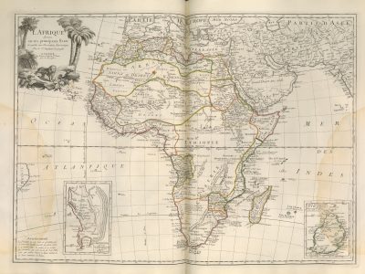
L’Afrique divisée en ses principaux Etats
Francesco Santini, Atlas universel dressé sur les meilleures cartes modernes, 1776
Title of the volume: Atlas universel dressé sur les meilleures cartes modernes (Universal Atlas Drawn from the Best Modern Maps)
Date: 1776
Author: Francesco Santini (18th century); Jean Janvier (1746-1782)
Engraver/printer: Domenico Baratti (18th century)
Publisher and place of publication: Paolo Santini, Venice
Plate execution technique: chalcography with hand watercoloring
Language: French
Location: Geography Library, ATL. PRE 10.1-2
Notes on the volume: The atlas, printed in Venice by Santini, is divided into two volumes of 60 and 63 maps respectively. The plate relating to the African continent is the thirty-ninth of the second volume. The author essentially copies the Atlas Universel by Gilles and Didier Robert de Vaugondy, published in Paris in 1757, without modifying the toponyms and inscriptions in French. Only in the maps relating to Italy he make some changes. Few copies of Santini’s atlas were published and it did not have much editorial success. On June 22, 1784, the copperplates were purchased by the Remondini: that same year the atlas was reprinted, adding 8 maps to the first volume and 4 to the second. The copy in the Geography Library was acquired in 1924, when Prof. Arrigo Lorenzi was director of the Geography Department.
GEO-CARTOGRAPHIC DATA
Scale: Approximately 1:21,000,000
Graphic scale: –
Orientation: North at the top
Size: 471 x 642 cm (matrix imprint)
Descriptive notes and regional divisions: At the top left, a cartouche shows the title of the map, accompanied by the annotation “Assujettie aux Observations Astronomique Par le Sr. Janvier Geographe” (“Subject to Astronomical Observations By Mr. Janvier Geographer”). It is framed by a decorative vignette consisting of a rock spur on which a lion rests and from which a pair of palms rises on each side. The longitude is referenced to the Meridian of Ferro Island. The relief is rendered in molehill style. Cities are indicated by a small white circle surmounted by a vertical line. At the bottom right, an auxiliary map made by Abbé de la Caille in 1753 at a scale of 1:100,000 represents the “Ile de France” (present-day Mauritius); by the same author is the auxiliary map of the Cape of Good Hope and surroundings at a scale of 1:2,000 placed on the left, dating 1753. Also at the bottom left, an inscription reads: “Avertissement. La Projection de cette Carte ne permettant pas de dresser une Echelle generale qui puisse servir a en mesures toutes les parties, on se servira des Latitudes qui sont tracees de 5 en 5. Deʹ grès qui valent chacun 20 lieues marines ou 25 lieues communes de France” (“Notice. As the Projection of this Map does not allow for drawing up a general Scale that can be used to measure all its parts, one will use the Latitudes which are traced from 5 to 5 Degrees, each worth 20 marine leagues or 25 common leagues of France”).
The hand-watercolored borders highlight the main territorial entities: along the Mediterranean coast, from west to east, we find the “Kingdom of Morocco”, the “Kingdom of Algiers”, “Tunis”, the “Republic of Tripoli” and “Egypt”; immediately to the south, the long strip of “Bile d’Ulgerid or Country of Dates”; further south is the vast “Sahara or Desert of Barbary”. This entire area, excluding Egypt, is in turn part of the vast natural region of “Barbary”. Going further south, we find “Nigritia” and, even further south, “Guinea”. From Egypt, moving southward, we encounter in order “Turkish Nubia”, “Nubia” and “Abyssinia”; the center of the continent is occupied by “Ethiopia”, to the east of which, along the coast, are the “Coast of Ajan” in the Horn of Africa and the “Coast of Zanzibar” further south; this is separated from the vast “Kaffraria”, which occupies much of southern Africa, by the “Empire of Monomotapa”, and the kingdoms of “Sofala”, “Manica” and “Sabia”. In the Indian Ocean is the “Isle of Madagascar”. In the specific area of the Sahel, further territorial subdivisions are identifiable: among others, in “Nigritia” we find the Kingdoms of “Mandinga”, “Tombut”, “Gago”, “Lanlem”, “Faran”, “Ghana”, “Bournou” and “Vangara”; in Guinea, in the wider region of Senegal, we find, among others, the small kingdoms of “Alichandara”, the “Foules”, the “Jalofes”, the “Pepper Coast”, the “Ivory Coast”, the “Gold Coast” and the “Coast of Ardra”.
Regarding hydrography, in the northern part of “Ethiopia” the Mountains of the Moon are still located, with two lakes at their feet from which the Nile originates: a note specifies that Ptolemy and the Orientals place the sources of the Nile here. Along the course of the Nile, in Turkish Nubia, the “Great Cataract” is indicated, the second of six present along the course of the Nile, today completely submerged in Lake Nasser (21°28′48″N 30°58′12″E). The inland river “Nile of the Negroes” connects “Lake Bournou” to a point not far from “Lake Tinu”, without it being certain which direction it flows. The Congo basin appears rather articulated. In the Sahel area, specifically in Nigritia, at the foot of the “Teloue” mountains, the Senegal River is born, which, after collecting the waters of various tributaries, reaches the Atlantic Ocean; in the “Marais” lake, on the other hand, the Niger is born, which initially flowing northeast traces its arc at the height of Tombut (Timbuktu) and proceeds eastward, bifurcating in the final stretch of its course, which ends in the two lakes on which Reghebil and Semegonda face.
Bibliography
Cusimano G. & D’Agostino G., eds. (1986). L’Africa ritrovata. Antiche carte geografiche dal XVI al XIX secolo. Palermo, Quaderni del “Servizio Museografico” della Facoltà di Lettere e Filosofia dell’Università di Palermo: p. 99.
Vladimiro V. (1997). Late Eighteenth and Early Nineteenth Century Italian Atlas. In: Wolter J.A. & Grim R.E., eds., Images of the World. Washington, Library of Congress: 257-300.
Vladimiro V., ed. (2007). Cartografi veneti. Mappe, uomini e istituzioni per l’immagine e il governo del territorio. Padova, Editoriale programma.
Reference websites
Phaidra (Permanent Hosting, Archiving and Indexing of Digital Resources and Assets), piattaforma del Sistema Bibliotecario di Ateneo per l’archiviazione a lungo termine di oggetti e collezioni digitali: https://phaidra.cab.unipd.it/detail/o:328433?mycoll=o:332208