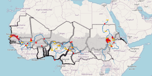
29- Another cartographic synthesis: the cages
This map includes many of the aspects that stifle the Sahel, forcing it to breathe with difficulty, imprisoned in rigid cages. Among these, first and foremost are state borders, which divide the Sahel into territorial traps (Agnew, 1994, 2015). Other traps capture water, such as dams on major rivers and large irrigation systems. To make the latter more visible at the regional scale, we have used hexagons to indicate areas of interest (AOIs) for both pivot and surface irrigation systems.